-
current
recommendations- Liefdefjord
New page dedicated to one of Spitsbergen's most beautiful fjords. Background information and many photos.
- New Spitsbergen guidebook
The new edition of my Spitsbergen guidebook is out and available now!
- Liefdefjord
New page dedicated to one of Spitsbergen's most beautiful fjords. Background information and many photos.
Page Structure
-
Spitsbergen-News
- Select Month
- May 2025
- April 2025
- March 2025
- February 2025
- January 2025
- December 2024
- November 2024
- October 2024
- September 2024
- August 2024
- July 2024
- June 2024
- May 2024
- April 2024
- March 2024
- February 2024
- January 2024
- December 2023
- November 2023
- October 2023
- September 2023
- August 2023
- July 2023
- June 2023
- May 2023
- April 2023
- March 2023
- February 2023
- January 2023
- December 2022
- November 2022
- October 2022
- September 2022
- August 2022
- July 2022
- June 2022
- May 2022
- April 2022
- March 2022
- February 2022
- January 2022
- December 2021
- November 2021
- October 2021
- September 2021
- August 2021
- July 2021
- June 2021
- May 2021
- April 2021
- March 2021
- February 2021
- January 2021
- December 2020
- November 2020
- October 2020
- September 2020
- August 2020
- July 2020
- June 2020
- May 2020
- April 2020
- March 2020
- February 2020
- January 2020
- December 2019
- November 2019
- October 2019
- September 2019
- August 2019
- July 2019
- June 2019
- May 2019
- April 2019
- March 2019
- February 2019
- January 2019
- December 2018
- November 2018
- October 2018
- September 2018
- August 2018
- July 2018
- June 2018
- May 2018
- April 2018
- March 2018
- February 2018
- January 2018
- December 2017
- November 2017
- October 2017
- September 2017
- August 2017
- July 2017
- June 2017
- May 2017
- April 2017
- March 2017
- February 2017
- January 2017
- December 2016
- November 2016
- October 2016
- September 2016
- August 2016
- July 2016
- June 2016
- May 2016
- April 2016
- March 2016
- February 2016
- January 2016
- December 2015
- November 2015
- October 2015
- September 2015
- August 2015
- July 2015
- June 2015
- May 2015
- April 2015
- March 2015
- February 2015
- January 2015
- December 2014
- November 2014
- October 2014
- September 2014
- August 2014
- July 2014
- June 2014
- May 2014
- April 2014
- March 2014
- February 2014
- January 2014
- December 2013
- November 2013
- October 2013
- September 2013
- August 2013
- July 2013
- June 2013
- May 2013
- April 2013
- March 2013
- February 2013
- January 2013
- December 2012
- November 2012
- October 2012
- September 2012
- August 2012
- July 2012
- June 2012
- May 2012
- April 2012
- March 2012
- February 2012
- January 2012
- December 2011
- November 2011
- October 2011
- September 2011
- August 2011
- May 2011
- April 2011
- March 2011
- February 2011
- January 2011
- December 2010
- November 2010
- September 2010
- August 2010
- July 2010
- June 2010
- May 2010
- April 2010
- March 2010
- February 2010
- November 2009
- October 2009
- August 2009
- July 2009
- June 2009
- May 2009
- April 2009
- March 2009
- February 2009
- January 2009
- December 2008
- November 2008
- October 2008
- August 2008
- July 2008
- June 2008
- May 2008
- April 2008
- March 2008
- February 2008
- April 2000
- Select Month
-
weather information
-
Newsletter

| Guidebook: Spitsbergen-Svalbard |
Home → December, 2011
Monthly Archives: December 2011 − News & Stories
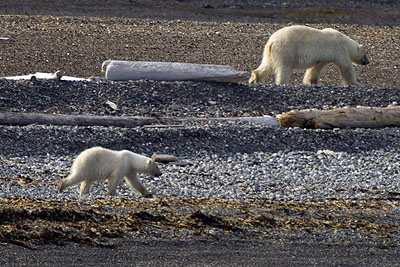
Polar bears
An interesting article about polar bears in the light of climate change has been published by the Russian Academy of Science. Click here to read the article.
Little polar bear family in northern Spitsbergen. Polar bears have to cope with climate change and environmental toxins and face accordingly an uncertain future.
Libya and the north pole
The new Libyan government has announced a flight to the north pole together with representatives of NATO member states that took part in the 2011 military campaign. The flight aims at an increase of the feeling for togetherness within the Libyan society and a positive reception in the world public.
The Sysselmannen has, however, denied permission for a fuel stop in Longyearbyen. The organizers of the flight said they were disappointed and would try to take the issue up to a political level.
Longyearbyen airport: Not available to the Libyan government on their way to the north pole.
Spitsbergen: UNESCO world heritage site?
Parts of Spitsbergen may be added to the world heritage site list of the UNESCO. In 2012, a working group of the Norwegian government will start to compile an application that can be submitted to the UNESCO at a later stage.
Spitsbergen: Unique nature and history and thus a potential UNESCO world heritage site. Here remains of a blubber oven from 17th century whaling at Smeerenburg.
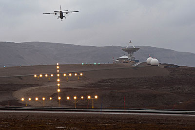
Ny Ålesund: new geodetic station
Until now the geodetic station in Ny Ålesund is situated near the airfield, about 1 km from the village. The Norwegian topographic agency that is running the station intends to build a new station near the coast at Brandalspynten, a peninsula not far from Ny Ålesund. This is controversial because there is a general consensus that the environment near Ny Ålesund is to be kept in a natural condition as much as possible, to preserve the ecological and scientific values. The Norwegian ministry for the environment has now announced that permission will be given to build the new station.
It is expected that 5 years will be needed to build the new station and both stations will run parallel for 3 years to synchronize the data.
The old geodetic station at the airfield near Ny Ålesund
New coal mine at Lunckefjellet
The Norwegian department of economy and trade has announced that permission for a new coal mine at Lunckefjellet will be given. The mining company Store Norske Spitsbergen Kullkompani (SNSK) has applied for this permission to replace the mines at Sveagruva, which are declining in terms of quality and quantity of coal. The department has mentioned mainly economical reaons.
The Norwegian department of economy and trade is the most important shareholder of the SNSK.
Opening a new mine close to a national park is a controversial matter. The Norwegian government keeps saying it wants Svalbard to become “the best administered wilderness in the world” and pushes to close major areas to the public (see first December note). To the Norwegian government, opening a new mine near a ecologically very important tundra area seems to be less environmentally harmfull than small boats, rubber boots and limited visitor numbers in barren areas.
Environmental obligations, including a cleanup after the end of mining activities, are part of the permission.
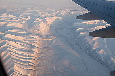
Reindalen. The new mine will be directly south of it (right side).
Source: Norwegisches Wirtschafts- und Handelsministerium
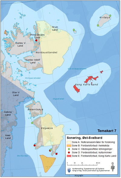
East Svalbard
The working group of the Sysselmannen has produced a map as a base for the ongoing discussion about a management plan for east Svalbard. The current proposal will be forwarded to the Norwegian directorate for nature administration in January 2012. Later, it will go through another public hearing. The map below is the basis for the current proposal.

The current proposal distinguishes several zones for eastern Svalbard:
Zone A: »scientific reference area«, which will most likely be a no go area for everybody except a few scientists selected by the administration.
Zone B: No traffic during the breeding season.
Zone C: specific site-specific guidelines
Zone D: local bans on traffic at cultural heritage sites, in force since 2010
Zone E: Kong Karls Land (already off limits)
Map: Sysselmannen
Source: Sysselmannen
News-Listing live generated at 2025/May/02 at 21:55:16 Uhr (GMT+1)


