


-
current
recommendations- Liefdefjord
New page dedicated to one of Spitsbergen's most beautiful fjords. Background information and many photos.

- New Spitsbergen guidebook
The new edition of my Spitsbergen guidebook is out and available now!

- Liefdefjord
New page dedicated to one of Spitsbergen's most beautiful fjords. Background information and many photos.
-
weather information

| Guidebook: Spitsbergen-Svalbard |
Home → * News and Stories → Digital Svalbard map freely available from 2015
Digital Svalbard map freely available from 2015
It would almost be too good to be true: The Norwegian Kartverket (the mapping authority) has announced that digital maps will stepwise be made available to the public for free use. Maps from mainland Norway will make a start in October 2013. Svalbard is to follow in 2015.
Until now, the policy regarding digital Svalbard maps was very restrictive and has received strong critizism. There is a digi-map for sale (“Svalbard Topo-Explorer”) for more than 1000 NOK, but it is very inaccurate for large parts of Svalbard, and the purchase does not include any rights for use on the internet or in printed publications. So far, the copyright for use in print is astronomically expensive; for this reason, we have so far unfortunately not been able to use this map material in the guidebook Spitsbergen-Svalbard. There is an online version of the digital Svalbard map on the website of the Norwegian Polar Institute, which is very accurate, but it cannot be used offline, for example in GPS receivers in the field or for publications. Now there is hope for a real improvement from 2015.
According to the Kartverket, this step is meant to increase creativity and business use. Reason to smile for publishers and guidebook authors! 🙂
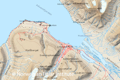
Digital map of Svalbard (screenshot from the website of the Norwegian Polar Institute): free use is announced to be possible from 2015, something that would be highly welcome for users in the field, publishers and digital economies.
Source: Computerworld
BOOKS, CALENDAR, POSTCARDS AND MORE
This and other publishing products of the Spitsbergen publishing house in the Spitsbergen-Shop.
-

Norwegens arktischer Norden (1): Spitzbergen
Photobook: Norway's arctic islands. The text in this book is German. [shop url="https://shop.spitzbergen.de/en/polar-books/70-norwegens-arktischer-norden-1-aerial-arctic-9783937903262.html"] ← BackOrder now -
Norwegens arktischer Norden (2): Aerial Arctic
Lofoten, Jan Mayen and Spitsbergen from the air - Photobook: Norway's arctic islands. The text in this book is German, but there is very little text, so I am sure that you will enjoy it regardless which languages you read (or not).Order now -
Poster “Svalbardhytter”
The poster "Svalbardhytter" (70 x 100 cm) visualizes the diversity of Spitsbergen's huts in a range of arctic landscapes.Order now -
Book “Svalbardhytter”
The companion book for the Svalbardhytter poster. The poster visualises the diversity of Spitsbergen‘s huts and their stories in a range of Arctic landscapes. The book tells the stories of the huts in three languages.Order now -
Spitsbergen – Svalbard. The complete guidebook
Comprehensive guidebook about Spitsbergen. Background (wildlife, plants, geology, history etc.), practical information including travelling seasons, how to travel, description of settlements, routes and regions.Order now -
Rocks and Ice. Landscapes of the North
A geographical traveling accompaniment to Spitsbergen and East Greenland (68-74°N). This is the English edition of the German book "Steine und Eis".Order now -
East Greenland in Winter
Join an exciting journey with dog, skis and tent through the wintery wastes of East Greenland! We were five guys and a dog when we started in Ittoqqortoormiit, the northernmost one of two settlements on Greenland’s east coast.Order now -
Postcard set Spitsbergen (Svalbard)
12 Spitsbergen postcards in a beautifully designed tray. Individually numbered limited edition!Order now -
Limited edition postcard set Antarctica
12 postcards which come in a beautifully designed tray. Beautiful images from South Georgia across Antarctica from the Antarctic Peninsula to the Ross Sea and up to Macquarie Island and Campbell Island.Order now
last modification: 2014-07-01 ·
copyright: Rolf Stange
-
Books, Calendar, Postcards and more

-


