


-
current
recommendations- Liefdefjord
New page dedicated to one of Spitsbergen's most beautiful fjords. Background information and many photos.

- New Spitsbergen guidebook
The new edition of my Spitsbergen guidebook is out and available now!
- Liefdefjord
New page dedicated to one of Spitsbergen's most beautiful fjords. Background information and many photos.
-
weather information

| Guidebook: Spitsbergen-Svalbard |
Home → * News and Stories → Houses in Longyearbyen evacuated: residual risk of avalanches too high despite local warning system
Houses in Longyearbyen evacuated: residual risk of avalanches too high despite local warning system
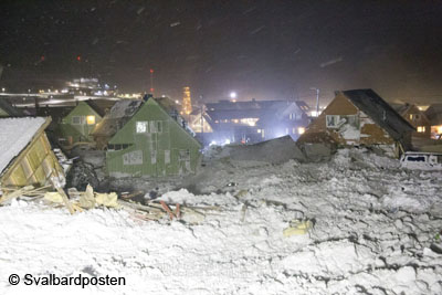
Soon it will be two years ago that the avalanche came down from the mountain Sukkertoppen that destroyed eleven houses and took two lives. There will be a memorial ceremony in Longyearbyen on the day, 19 December.
The avalanche area in Longyearbyen in December 2015. Two people were killed and eleven houses destroyed. One was moved as much as 80 metres. Photo © Svalbardposten.
There has been – and still is – a lot of talking about the avalanche risk in Longyearbyen on all levels. It seems obvious that there have been neglects on various public levels, but it was said officially that there is no institution or individual that may legally be held responsible.
And there is, of course, the question of how to deal with the avalanche risk in future. An official report about the avalanche situation has determined that a large number of houses in Longyearbyen is exposed to various levels of avalanche risk. A local warning system has been established, which has produced mixed results so far; on one occasion, the system produced a false security statement that was spectacularly wrong. Two houses were destroyed on that occasion, and it was a matter of luck that there was no loss of human life. Instruments to measure the thickness of the snow layer have been installed on various slopes close to Longyearbyen. These instruments are supposed to provide real-time data about snow accumulation in locations where people had to measure manually in the past, something that is often difficult or even impossible in situations of severe weather when an increased risk has to be assumed. But that is obviously exactly when you need that kind of data, so these new decives are expect to make a significant improvement to the avalanche warning system.
Avalanche barriers are another measure expected in the future, but they are not there yet, almost two years after the big, tragic 2015 event. Evacuating parts of Longyearbyen, on a situative or permanent basis, is also one of the options which are discussed. The financial aspects of all that is yet another issue.
It does, however, not cost the public much to evacuate certain addresses on a preventive basis. Evacuating parts of Longyearbyen has become a standard procedure during winters since late 2015. Yesterday (14 December), the Sysselmannen has issued an order that certain addresses have to be left until 22 December until further notice. This measure is expected to be in force until the snow is gone, which means, the houses will not be available for months.

These parts of Longyearbyen (marked red) will be evacuated from 22 December until further notice. The complete map is available from the Sysselmannen.
So far, evacuations were made in or before an actual risk situation, based on snow conditions, weather forecasts etc. This time, however, there is no such base for the evacuation, something that becomes clear from the time span of 8 days between the issue of the evacuation order and the date (22 Dec) when it actually enters force. Sysselmannen Kjerstin Askholt says “The ban on traffic is based on the risk evaluation for individuals and public safety, because this area is especially exposed to avalanches. The current practice with a local avalanche warning system and possible evacuations, based on technical advice from avalanche experts, does not exclude a high residual risk and remaining uncertainties, so the houses in question can not be used while there are no measures for avalanche safety in place” (Sysselmannen, auhtor’s translation).
Areas concerned are addresses in way 222 and 226, which are located directly next to the mountain Sukkertoppen, but may be extended to other areas at any time as deemed necessary by authorities.
Evacuating a number of houses for a longer period of time based on general precautionary reasons rather than an actual risk situation appears to be a drastic step, compared to the impact that this has on the lives of those who have to leave their homes for months. There are those who have, next to their home in the area concerned, rented a place elsewhere in Longyearbyen on a permanent basis, something that obviously involves high costs and this is not a contribution to the already difficult housing market in Longyearbyen either. Those who own a place in the area that is affected, are also faced with a substantially difficult situation.
Not a glorious chapter for politics, considering the current development started with the avalance in December 2015 – two years ago.
Source: Sysselmannen
BOOKS, CALENDAR, POSTCARDS AND MORE
This and other publishing products of the Spitsbergen publishing house in the Spitsbergen-Shop.
-

Norwegens arktischer Norden (1): Spitzbergen
Photobook: Norway's arctic islands. The text in this book is German. [shop url="https://shop.spitzbergen.de/en/polar-books/70-norwegens-arktischer-norden-1-aerial-arctic-9783937903262.html"] ← BackOrder now -
Norwegens arktischer Norden (2): Aerial Arctic
Lofoten, Jan Mayen and Spitsbergen from the air - Photobook: Norway's arctic islands. The text in this book is German, but there is very little text, so I am sure that you will enjoy it regardless which languages you read (or not).Order now -
Poster “Svalbardhytter”
The poster "Svalbardhytter" (70 x 100 cm) visualizes the diversity of Spitsbergen's huts in a range of arctic landscapes.Order now -
Book “Svalbardhytter”
The companion book for the Svalbardhytter poster. The poster visualises the diversity of Spitsbergen‘s huts and their stories in a range of Arctic landscapes. The book tells the stories of the huts in three languages.Order now -
Spitsbergen – Svalbard. The complete guidebook
Comprehensive guidebook about Spitsbergen. Background (wildlife, plants, geology, history etc.), practical information including travelling seasons, how to travel, description of settlements, routes and regions.Order now -
Rocks and Ice. Landscapes of the North
A geographical traveling accompaniment to Spitsbergen and East Greenland (68-74°N). This is the English edition of the German book "Steine und Eis".Order now -
East Greenland in Winter
Join an exciting journey with dog, skis and tent through the wintery wastes of East Greenland! We were five guys and a dog when we started in Ittoqqortoormiit, the northernmost one of two settlements on Greenland’s east coast.Order now -
Postcard set Spitsbergen (Svalbard)
12 Spitsbergen postcards in a beautifully designed tray. Individually numbered limited edition!Order now -
Limited edition postcard set Antarctica
12 postcards which come in a beautifully designed tray. Beautiful images from South Georgia across Antarctica from the Antarctic Peninsula to the Ross Sea and up to Macquarie Island and Campbell Island.Order now
last modification: 2017-12-15 ·
copyright: Rolf Stange


-
Books, Calendar, Postcards and more

-


