-
current
recommendations- Liefdefjord
New page dedicated to one of Spitsbergen's most beautiful fjords. Background information and many photos.
- New Spitsbergen guidebook
The new edition of my Spitsbergen guidebook is out and available now!
- Liefdefjord
New page dedicated to one of Spitsbergen's most beautiful fjords. Background information and many photos.
Page Structure
-
Spitsbergen-News
- Select Month
- May 2025
- April 2025
- March 2025
- February 2025
- January 2025
- December 2024
- November 2024
- October 2024
- September 2024
- August 2024
- July 2024
- June 2024
- May 2024
- April 2024
- March 2024
- February 2024
- January 2024
- December 2023
- November 2023
- October 2023
- September 2023
- August 2023
- July 2023
- June 2023
- May 2023
- April 2023
- March 2023
- February 2023
- January 2023
- December 2022
- November 2022
- October 2022
- September 2022
- August 2022
- July 2022
- June 2022
- May 2022
- April 2022
- March 2022
- February 2022
- January 2022
- December 2021
- November 2021
- October 2021
- September 2021
- August 2021
- July 2021
- June 2021
- May 2021
- April 2021
- March 2021
- February 2021
- January 2021
- December 2020
- November 2020
- October 2020
- September 2020
- August 2020
- July 2020
- June 2020
- May 2020
- April 2020
- March 2020
- February 2020
- January 2020
- December 2019
- November 2019
- October 2019
- September 2019
- August 2019
- July 2019
- June 2019
- May 2019
- April 2019
- March 2019
- February 2019
- January 2019
- December 2018
- November 2018
- October 2018
- September 2018
- August 2018
- July 2018
- June 2018
- May 2018
- April 2018
- March 2018
- February 2018
- January 2018
- December 2017
- November 2017
- October 2017
- September 2017
- August 2017
- July 2017
- June 2017
- May 2017
- April 2017
- March 2017
- February 2017
- January 2017
- December 2016
- November 2016
- October 2016
- September 2016
- August 2016
- July 2016
- June 2016
- May 2016
- April 2016
- March 2016
- February 2016
- January 2016
- December 2015
- November 2015
- October 2015
- September 2015
- August 2015
- July 2015
- June 2015
- May 2015
- April 2015
- March 2015
- February 2015
- January 2015
- December 2014
- November 2014
- October 2014
- September 2014
- August 2014
- July 2014
- June 2014
- May 2014
- April 2014
- March 2014
- February 2014
- January 2014
- December 2013
- November 2013
- October 2013
- September 2013
- August 2013
- July 2013
- June 2013
- May 2013
- April 2013
- March 2013
- February 2013
- January 2013
- December 2012
- November 2012
- October 2012
- September 2012
- August 2012
- July 2012
- June 2012
- May 2012
- April 2012
- March 2012
- February 2012
- January 2012
- December 2011
- November 2011
- October 2011
- September 2011
- August 2011
- May 2011
- April 2011
- March 2011
- February 2011
- January 2011
- December 2010
- November 2010
- September 2010
- August 2010
- July 2010
- June 2010
- May 2010
- April 2010
- March 2010
- February 2010
- November 2009
- October 2009
- August 2009
- July 2009
- June 2009
- May 2009
- April 2009
- March 2009
- February 2009
- January 2009
- December 2008
- November 2008
- October 2008
- August 2008
- July 2008
- June 2008
- May 2008
- April 2008
- March 2008
- February 2008
- April 2000
- Select Month
-
weather information
-
Newsletter

| Guidebook: Spitsbergen-Svalbard |
Home → * News and Stories → Data connection cable to mainland damaged
Data connection cable to mainland damaged
Many, many years ago, ships were needed to send messages from Spitsbergen to the world and vice versa. The wireless telegraph station built in 1911 at Finneset made communication considerably more efficient. Further techical upgrades followed throughout the 20th century.
But this kind of connection, although perfectly fine for the everyday needs of mining companies, expeditions and fishing and other ships, was far from good enough for the traffic that arose when SvalSat was established in 1997: a station with a collection of satellite antennas to send data to satellites and receive data traveling the opposite way. The number of antennas at SvalSat has increased ever since and is now amounting to something near 100.

Satellite antennas of SvalSat on Platåberg near Longyearbyen.
As customers like NASA and ESA don’t like to wait until a data DVD or USB stick is shipped out to them, a fibre cable was laid to the mainland in 2004 to transport large volumes of data in real time. It is actually a set of two indipendent cables to create redundancy and thus a robust structure. Since these cables exist, Longyearbyen has super-fast internet (although the user experience of more mertals may occasionally be different).
The two cables on the sea floor are a very important and sensitive bit of infrastructure. Almost all communication of all of Spitsbergen’s settlements depends on them, as well as the data traffic that is going through SvalSat: controlling satellites in polar orbits and receiving their data when they are needed. Navigation, communication, science, weather – the whole lot, everything that satellites do these days. Obviously an important bit of global infrastructure.
Last Friday, one of the cables was damaged in the early morning, as the operating company Space Norway notified in a press release. A sea-going cable laying vessel is needed to repair the damage, and it will take time until this is done.
The second cable is enough to cater for all data traffic and there are no restrictions as long as it is operative. But there is no further redundance, and a loss of the second cable would have huge consequences. A crisis management group had a first meeting in Longyearbyen to discuss scenarios “in case”. Officials emphasise, however, that there is no reason to believe that a loss of the second cable is likely to happen.
The damage seems to have occured at a distance between 120-130 km from Longyearbyen, in an area where depth is falling from the shallower shelf to the deep sea. The continental shelf is an area where huge mass movements naturally occur from time to time, so the damage may have been caused by a natural event. But no further details are known so far, and authorities do not exclude criminally relevant action of third parties, according to NRK.
The case reminds of the mysterious loss of a cable connection of research installations on the sea floor off north Norway. Last year, the “Lofoten-Vesterålen Meeresobservatorium”, or short: “LoVe” suddenly turned black. LoVe is a civilian research facility designed to collect a rather comprehensive set of high-resolution data of various sorts, including acoustic data. LoVe is, in other words, capable of recording submarine traffic at least to some degree. It turned out that no less than 4 kilometres of cable were removed. 3 out of these 4 km of cable were later found in a distance of a good 10 km from the original site. A natural cause for the event can, as of now, not be excluded, although all options considered (including currents, giant squid or whales) sound more or less bizarre. Bottom trawling can not be ruled out either, but it is hard to imagine that this would have happened unnoticed.

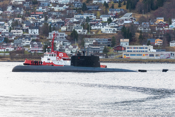
There is a lot of submarine traffic off Norway. Not all of them operate as much in public as this submarine that is here seen being towed in the harbour of Tromsø.
In this context, remarks have been made that Russia is technically capable of operations on the sea floor at relevant depths. Norwegian authorities including the secret service are involved in the investigations, as was reported by NRK and international media such as German SPIEGEL Online.
These cases shed a different kind of light on the desire of the Norwegian military to control high-resolution mapping of the Norwegian sea floor including Svalbard and Jan Mayen.
BOOKS, CALENDAR, POSTCARDS AND MORE
This and other publishing products of the Spitsbergen publishing house in the Spitsbergen-Shop.
last modification: 2022-01-11 ·
copyright: Rolf Stange


