


-
current
recommendations- Liefdefjord
New page dedicated to one of Spitsbergen's most beautiful fjords. Background information and many photos.

- New Spitsbergen guidebook
The new edition of my Spitsbergen guidebook is out and available now!
- Liefdefjord
New page dedicated to one of Spitsbergen's most beautiful fjords. Background information and many photos.
-
weather information

| Guidebook: Spitsbergen-Svalbard |
Home → * News and Stories → Arctic sea ice: 2013 more than 2012, but long-term negative trend unbroken
Arctic sea ice: 2013 more than 2012, but long-term negative trend unbroken
The area of arctic sea ice has been monitored by satellite for 34 years not, but the European satellite Cryosat, operative for 3 years now, is able to measure not only area, but also the thickness of the ice, giving scientists much more precise and reliable data to monitor the development of arctic sea ice. Before Cryosat, data about ice thickness had to be collected manually, giving only control samples with great effort.
2012 remains so far the minimum year for arctic sea ice, both in terms of area and volume. In October 2012, there were about 6,000 cubic kilometres (km3) of sea ice in the Arctic, compared to 9,000 at the same time in 2013. This means an increase of 50 %. Most of the increase is due to an increased thickness of multi-year ice, which is currently mostly two year ice, by 20 % or 30 cm. The proportion of multi year ice is, however, still significantly lower than it used to be.
The interpretation of these data is that 2012 was an extreme negative year, due to persistent strong winds that pushed a lot of sea ice out of the Arctic Ocean and into the North Atlantic, where it melted quickly. There is no indication of a change of the long-term negative trend, and the Arctic is still expected to be ice-free in summer within a few decades – some predictions even talk about a few years only.
In comparison, the sea ice volume of the early 1980s is estimated near 20,000 km3, more than double compared to the present value.
Sea ice in the Arctic: more than 2012, but much less than 30 years ago.
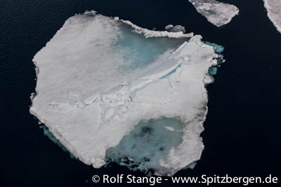
Source: ESA
BOOKS, CALENDAR, POSTCARDS AND MORE
This and other publishing products of the Spitsbergen publishing house in the Spitsbergen-Shop.
-

Norwegens arktischer Norden (1): Spitzbergen
Photobook: Norway's arctic islands. The text in this book is German. [shop url="https://shop.spitzbergen.de/en/polar-books/70-norwegens-arktischer-norden-1-aerial-arctic-9783937903262.html"] ← BackOrder now -
Norwegens arktischer Norden (2): Aerial Arctic
Lofoten, Jan Mayen and Spitsbergen from the air - Photobook: Norway's arctic islands. The text in this book is German, but there is very little text, so I am sure that you will enjoy it regardless which languages you read (or not).Order now -
Poster “Svalbardhytter”
The poster "Svalbardhytter" (70 x 100 cm) visualizes the diversity of Spitsbergen's huts in a range of arctic landscapes.Order now -
Book “Svalbardhytter”
The companion book for the Svalbardhytter poster. The poster visualises the diversity of Spitsbergen‘s huts and their stories in a range of Arctic landscapes. The book tells the stories of the huts in three languages.Order now -
Spitsbergen – Svalbard. The complete guidebook
Comprehensive guidebook about Spitsbergen. Background (wildlife, plants, geology, history etc.), practical information including travelling seasons, how to travel, description of settlements, routes and regions.Order now -
Rocks and Ice. Landscapes of the North
A geographical traveling accompaniment to Spitsbergen and East Greenland (68-74°N). This is the English edition of the German book "Steine und Eis".Order now -
East Greenland in Winter
Join an exciting journey with dog, skis and tent through the wintery wastes of East Greenland! We were five guys and a dog when we started in Ittoqqortoormiit, the northernmost one of two settlements on Greenland’s east coast.Order now -
Postcard set Spitsbergen (Svalbard)
12 Spitsbergen postcards in a beautifully designed tray. Individually numbered limited edition!Order now -
Limited edition postcard set Antarctica
12 postcards which come in a beautifully designed tray. Beautiful images from South Georgia across Antarctica from the Antarctic Peninsula to the Ross Sea and up to Macquarie Island and Campbell Island.Order now
last modification: 2014-07-01 ·
copyright: Rolf Stange


-
Books, Calendar, Postcards and more

-


