


-
current
recommendations- Liefdefjord
New page dedicated to one of Spitsbergen's most beautiful fjords. Background information and many photos.

- New Spitsbergen guidebook
The new edition of my Spitsbergen guidebook is out and available now!
- Liefdefjord
New page dedicated to one of Spitsbergen's most beautiful fjords. Background information and many photos.
-
weather information

| Guidebook: Spitsbergen-Svalbard |
Home → * News and Stories → Hopen: discoverer Marmaduke finally on the map
Hopen: discoverer Marmaduke finally on the map
The little island Hopen in southeastern Svalbard was, as far as known, discovered in 1613 by the English whaler Thomas Marmaduke. The island was subsequently named after his ship, the Hopewell, but the name of the discoverer did not make it on the map.
This scandal has caught the attention of the crew of the Norwegian weather on Hopen, who decided, in the year of the 400th anniversary of the discovery, to file a request to the Norwegian Polar Institute (NPI) to get something done about it. It was the station cook who sent the application, and an appropriate, as so far nameless, topographic feature was duly found: a little gully on the west side of the island, just a few hundred metres from the station. The name giving committee of the NPI agreed, and the gully in question bears now officially the name Marmadukeskaret (Marmaduke gully).
The name giving committee meets twice every year to decide officially about new place names which then appear on the topographic map. Basically, everybody can file suggestions. Names of living persons have, however, hardly any chance to be accepted.
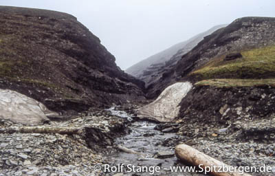
Gully on the island Hopen. Not the one now named after Marmaduke, but that one is quite similar. A bit smaller.
Source: Hopenmeteo
BOOKS, CALENDAR, POSTCARDS AND MORE
This and other publishing products of the Spitsbergen publishing house in the Spitsbergen-Shop.
-

Norwegens arktischer Norden (1): Spitzbergen
Photobook: Norway's arctic islands. The text in this book is German. [shop url="https://shop.spitzbergen.de/en/polar-books/70-norwegens-arktischer-norden-1-aerial-arctic-9783937903262.html"] ← BackOrder now -
Norwegens arktischer Norden (2): Aerial Arctic
Lofoten, Jan Mayen and Spitsbergen from the air - Photobook: Norway's arctic islands. The text in this book is German, but there is very little text, so I am sure that you will enjoy it regardless which languages you read (or not).Order now -
Poster “Svalbardhytter”
The poster "Svalbardhytter" (70 x 100 cm) visualizes the diversity of Spitsbergen's huts in a range of arctic landscapes.Order now -
Book “Svalbardhytter”
The companion book for the Svalbardhytter poster. The poster visualises the diversity of Spitsbergen‘s huts and their stories in a range of Arctic landscapes. The book tells the stories of the huts in three languages.Order now -
Spitsbergen – Svalbard. The complete guidebook
Comprehensive guidebook about Spitsbergen. Background (wildlife, plants, geology, history etc.), practical information including travelling seasons, how to travel, description of settlements, routes and regions.Order now -
Rocks and Ice. Landscapes of the North
A geographical traveling accompaniment to Spitsbergen and East Greenland (68-74°N). This is the English edition of the German book "Steine und Eis".Order now -
East Greenland in Winter
Join an exciting journey with dog, skis and tent through the wintery wastes of East Greenland! We were five guys and a dog when we started in Ittoqqortoormiit, the northernmost one of two settlements on Greenland’s east coast.Order now -
Postcard set Spitsbergen (Svalbard)
12 Spitsbergen postcards in a beautifully designed tray. Individually numbered limited edition!Order now -
Limited edition postcard set Antarctica
12 postcards which come in a beautifully designed tray. Beautiful images from South Georgia across Antarctica from the Antarctic Peninsula to the Ross Sea and up to Macquarie Island and Campbell Island.Order now
last modification: 2014-07-01 ·
copyright: Rolf Stange


-
Books, Calendar, Postcards and more

-


