


-
current
recommendations- Liefdefjord
New page dedicated to one of Spitsbergen's most beautiful fjords. Background information and many photos.

- New Spitsbergen guidebook
The new edition of my Spitsbergen guidebook is out and available now!
- Liefdefjord
New page dedicated to one of Spitsbergen's most beautiful fjords. Background information and many photos.
-
weather information

| Guidebook: Spitsbergen-Svalbard |
Home → * News and Stories → Man fell 6 metres into glacier crevasse on Conwayjøkulen
Man fell 6 metres into glacier crevasse on Conwayjøkulen
The similarity to the next to last headline is no coincidence: again, a skier fell down a crevasse on a glacier in Spitsbergen. And again, it went well in the end.
A group of five tourists led by one guide was on the way back from a trip to Newtontoppen, Spitsbergen’s highest mountain. In the area of Conwayjøkulen, northeast of Billefjord, the group got into crevassed area. At the time (Thursday, 16 April) the weather was bad in the area, with strong winds and drifting snow and visibility accordingly poor. The six skiers were roped up into two groups of three persons each, when the guide, leading the first group, well down into a crevasse. His two followers could, however, stop his fall after 6 metres. The second team approached the crevasse and finally managed to retrieve the emergency beacon, which the guide had with him.
Due to the poor visibility on the ground, the rescue helicopter was not able to land, despite several attempts. Rescue forces in Longyearbyen prepared a ski expedition, and the helicopter prepared to winch the six persons all up individually, when the weather improved slightly, allowing the helicopter to land. Meanwhile, the five skiers on the ground had managed to get their guide up from the crevasse. He had suffered light shoulder injuries, but was otherwise unhurt.
All six and their dog could then board the helicopter and return to Longyearbyen.
The exact position of the crevasse has not been published. The wide glacier areas of Lomonossovfonna are generally thought to have few crevasses only. It is possible that the group had ended up somewhere they would not have gone in better visibility. It is not known if the crevasse had been visible under better conditions.
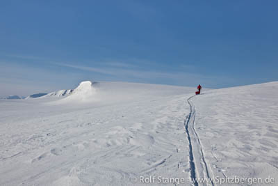
Glacier landscape in the area of Lomonossovfonna, not far from Conwayjøkulen, where a man fell 6 metres into a crevasse on Thursday.
Sources: Sysselmannen, Svalbardposten
BOOKS, CALENDAR, POSTCARDS AND MORE
This and other publishing products of the Spitsbergen publishing house in the Spitsbergen-Shop.
-

Norwegens arktischer Norden (1): Spitzbergen
Photobook: Norway's arctic islands. The text in this book is German. [shop url="https://shop.spitzbergen.de/en/polar-books/70-norwegens-arktischer-norden-1-aerial-arctic-9783937903262.html"] ← BackOrder now -
Norwegens arktischer Norden (2): Aerial Arctic
Lofoten, Jan Mayen and Spitsbergen from the air - Photobook: Norway's arctic islands. The text in this book is German, but there is very little text, so I am sure that you will enjoy it regardless which languages you read (or not).Order now -
Poster “Svalbardhytter”
The poster "Svalbardhytter" (70 x 100 cm) visualizes the diversity of Spitsbergen's huts in a range of arctic landscapes.Order now -
Book “Svalbardhytter”
The companion book for the Svalbardhytter poster. The poster visualises the diversity of Spitsbergen‘s huts and their stories in a range of Arctic landscapes. The book tells the stories of the huts in three languages.Order now -
Spitsbergen – Svalbard. The complete guidebook
Comprehensive guidebook about Spitsbergen. Background (wildlife, plants, geology, history etc.), practical information including travelling seasons, how to travel, description of settlements, routes and regions.Order now -
Rocks and Ice. Landscapes of the North
A geographical traveling accompaniment to Spitsbergen and East Greenland (68-74°N). This is the English edition of the German book "Steine und Eis".Order now -
East Greenland in Winter
Join an exciting journey with dog, skis and tent through the wintery wastes of East Greenland! We were five guys and a dog when we started in Ittoqqortoormiit, the northernmost one of two settlements on Greenland’s east coast.Order now -
Postcard set Spitsbergen (Svalbard)
12 Spitsbergen postcards in a beautifully designed tray. Individually numbered limited edition!Order now -
Limited edition postcard set Antarctica
12 postcards which come in a beautifully designed tray. Beautiful images from South Georgia across Antarctica from the Antarctic Peninsula to the Ross Sea and up to Macquarie Island and Campbell Island.Order now
last modification: 2014-07-01 ·
copyright: Rolf Stange


-
Books, Calendar, Postcards and more

-


