-
current
recommendations- Liefdefjord
New page dedicated to one of Spitsbergen's most beautiful fjords. Background information and many photos.
- New Spitsbergen guidebook
The new edition of my Spitsbergen guidebook is out and available now!
- Liefdefjord
New page dedicated to one of Spitsbergen's most beautiful fjords. Background information and many photos.
Page Structure
-
Spitsbergen-News
- Select Month
- June 2025
- May 2025
- April 2025
- March 2025
- February 2025
- January 2025
- December 2024
- November 2024
- October 2024
- September 2024
- August 2024
- July 2024
- June 2024
- May 2024
- April 2024
- March 2024
- February 2024
- January 2024
- December 2023
- November 2023
- October 2023
- September 2023
- August 2023
- July 2023
- June 2023
- May 2023
- April 2023
- March 2023
- February 2023
- January 2023
- December 2022
- November 2022
- October 2022
- September 2022
- August 2022
- July 2022
- June 2022
- May 2022
- April 2022
- March 2022
- February 2022
- January 2022
- December 2021
- November 2021
- October 2021
- September 2021
- August 2021
- July 2021
- June 2021
- May 2021
- April 2021
- March 2021
- February 2021
- January 2021
- December 2020
- November 2020
- October 2020
- September 2020
- August 2020
- July 2020
- June 2020
- May 2020
- April 2020
- March 2020
- February 2020
- January 2020
- December 2019
- November 2019
- October 2019
- September 2019
- August 2019
- July 2019
- June 2019
- May 2019
- April 2019
- March 2019
- February 2019
- January 2019
- December 2018
- November 2018
- October 2018
- September 2018
- August 2018
- July 2018
- June 2018
- May 2018
- April 2018
- March 2018
- February 2018
- January 2018
- December 2017
- November 2017
- October 2017
- September 2017
- August 2017
- July 2017
- June 2017
- May 2017
- April 2017
- March 2017
- February 2017
- January 2017
- December 2016
- November 2016
- October 2016
- September 2016
- August 2016
- July 2016
- June 2016
- May 2016
- April 2016
- March 2016
- February 2016
- January 2016
- December 2015
- November 2015
- October 2015
- September 2015
- August 2015
- July 2015
- June 2015
- May 2015
- April 2015
- March 2015
- February 2015
- January 2015
- December 2014
- November 2014
- October 2014
- September 2014
- August 2014
- July 2014
- June 2014
- May 2014
- April 2014
- March 2014
- February 2014
- January 2014
- December 2013
- November 2013
- October 2013
- September 2013
- August 2013
- July 2013
- June 2013
- May 2013
- April 2013
- March 2013
- February 2013
- January 2013
- December 2012
- November 2012
- October 2012
- September 2012
- August 2012
- July 2012
- June 2012
- May 2012
- April 2012
- March 2012
- February 2012
- January 2012
- December 2011
- November 2011
- October 2011
- September 2011
- August 2011
- May 2011
- April 2011
- March 2011
- February 2011
- January 2011
- December 2010
- November 2010
- September 2010
- August 2010
- July 2010
- June 2010
- May 2010
- April 2010
- March 2010
- February 2010
- November 2009
- October 2009
- August 2009
- July 2009
- June 2009
- May 2009
- April 2009
- March 2009
- February 2009
- January 2009
- December 2008
- November 2008
- October 2008
- August 2008
- July 2008
- June 2008
- May 2008
- April 2008
- March 2008
- February 2008
- April 2000
- Select Month
-
weather information
-
Newsletter

| Guidebook: Spitsbergen-Svalbard |
Home → Arctic blog: Jan Mayen, Spitsbergen → Towards Beerenberg
Towards Beerenberg
Sun
6 Jul
2014
Beerenberg is certainly more difficult than the altitude of a mere 2277 m suggests. Only on a handful of days in a year the weather is good enough to allow an ascent. And the logistics, difficult anyway, are a nightmare since the new regulations were introduced in 2010: no tents anywhere but Kvalrossbukta. If this benefits the environment (or science, for that sake), is another question, I guess I’ll return to that later.
This means that any attempt to climb Beerenberg will start for normal people (that is everybody unless you work at the station or you are officially supported by Norwegian authorities) with a hike of almost 20 km. And then you start the long ascent over rocky slopes and crevassed glaciers. Surely not everybodies cup of tea.
We have had our share of weather of all kinds both during the crossing and the first 24 hours on Jan Mayen, which was not too encouraging. Actually quite demanding. So for today, we had agreed with the station to pay them a visit to get a nice, not too long hike for the first real day here.
But Siggi (Sigurdur, the skipper) had got new weather information, which spoke a clear language. If an attempt on Beerenberg was to be made, it had to be tomorrow. If it was possible at all.
But there was only one way to find out. So we could not afford a rather relaxed day to get acclimatized, which would have been good. Instead, packing again. Equipment and food for bivac and glacier.
Gusty winds and rain showers were still hitting the tents, so we took it with time. We clearly did not have any desire to start wet into such an undertaking. We decided to make good use of the advantages of the midnight sun.
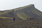
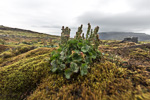
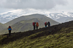
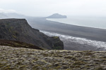
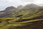
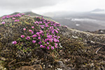
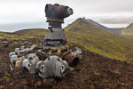
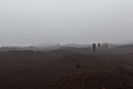
Finally it was time to start. Following the road for the first bit, we then went northwards over Pukkelryggen, a chain of mossy hills, old volcanic craters, one after another. Landscape in dark black, rusty read and strong mossy green, all threatened to be drowned in the heavy grey of today’s low clouds. We took a breath at a little stream, Purple saxifrage and Alpine mountain sorrel everywhere, flowers well-known from Spitsbergen, which appears as such a friendly place from the Jan Mayen perspective. Passing an old fighter airplane wreck from the mad days of WWII, behind it a foggy view to the northern lagoon. A shame just to walk past it today, but we still have many kilometres to go, the long way makes itself already felt, and so does the weight of the rucksacks.
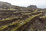
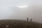
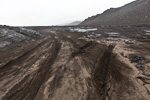
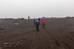
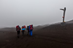
Some of us turn back at Jøssingdalen. Those who hope to climb Beerenberg continue into the fog northwards. The remaining four follow the road south. A last, easy chance to make a decision and turn one’s back to the volcanoe. Some of us are certainly considering, then a quick goodbye and on we go, disappearing into a moon-like landscape of black volcanic sand desert and lava fields, following the road which is winding its way between rocky outcrops. They have even set up a few road signs of driftwood.
- gallery anchor link: #gallery_487
Click on thumbnail to open an enlarged version of the specific photo.
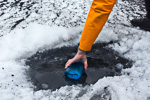
After a long 18 kilometres, we have reached Ekerolddalen. Quot licet iovi, non licet bovi – for some privileged individuals, this is the parking place, other may not even set up a camp. So we roll our sleeping bags out on volcanic sand. A snow patch delivers some water, so we can turn dried food into something like a hot meal and tea. I hope, the next couple of foggy hours here in Ekerolddalen bring some rest. We’ll need it tomorrow.
BOOKS, CALENDAR, POSTCARDS AND MORE
This and other publishing products of the Spitsbergen publishing house in the Spitsbergen-Shop.
last modification: 2014-07-14 ·
copyright: Rolf Stange

