-
current
recommendations- Liefdefjord
New page dedicated to one of Spitsbergen's most beautiful fjords. Background information and many photos.
- New Spitsbergen guidebook
The new edition of my Spitsbergen guidebook is out and available now!
- Liefdefjord
New page dedicated to one of Spitsbergen's most beautiful fjords. Background information and many photos.
Page Structure
-
Spitsbergen-News
- Select Month
- May 2025
- April 2025
- March 2025
- February 2025
- January 2025
- December 2024
- November 2024
- October 2024
- September 2024
- August 2024
- July 2024
- June 2024
- May 2024
- April 2024
- March 2024
- February 2024
- January 2024
- December 2023
- November 2023
- October 2023
- September 2023
- August 2023
- July 2023
- June 2023
- May 2023
- April 2023
- March 2023
- February 2023
- January 2023
- December 2022
- November 2022
- October 2022
- September 2022
- August 2022
- July 2022
- June 2022
- May 2022
- April 2022
- March 2022
- February 2022
- January 2022
- December 2021
- November 2021
- October 2021
- September 2021
- August 2021
- July 2021
- June 2021
- May 2021
- April 2021
- March 2021
- February 2021
- January 2021
- December 2020
- November 2020
- October 2020
- September 2020
- August 2020
- July 2020
- June 2020
- May 2020
- April 2020
- March 2020
- February 2020
- January 2020
- December 2019
- November 2019
- October 2019
- September 2019
- August 2019
- July 2019
- June 2019
- May 2019
- April 2019
- March 2019
- February 2019
- January 2019
- December 2018
- November 2018
- October 2018
- September 2018
- August 2018
- July 2018
- June 2018
- May 2018
- April 2018
- March 2018
- February 2018
- January 2018
- December 2017
- November 2017
- October 2017
- September 2017
- August 2017
- July 2017
- June 2017
- May 2017
- April 2017
- March 2017
- February 2017
- January 2017
- December 2016
- November 2016
- October 2016
- September 2016
- August 2016
- July 2016
- June 2016
- May 2016
- April 2016
- March 2016
- February 2016
- January 2016
- December 2015
- November 2015
- October 2015
- September 2015
- August 2015
- July 2015
- June 2015
- May 2015
- April 2015
- March 2015
- February 2015
- January 2015
- December 2014
- November 2014
- October 2014
- September 2014
- August 2014
- July 2014
- June 2014
- May 2014
- April 2014
- March 2014
- February 2014
- January 2014
- December 2013
- November 2013
- October 2013
- September 2013
- August 2013
- July 2013
- June 2013
- May 2013
- April 2013
- March 2013
- February 2013
- January 2013
- December 2012
- November 2012
- October 2012
- September 2012
- August 2012
- July 2012
- June 2012
- May 2012
- April 2012
- March 2012
- February 2012
- January 2012
- December 2011
- November 2011
- October 2011
- September 2011
- August 2011
- May 2011
- April 2011
- March 2011
- February 2011
- January 2011
- December 2010
- November 2010
- September 2010
- August 2010
- July 2010
- June 2010
- May 2010
- April 2010
- March 2010
- February 2010
- November 2009
- October 2009
- August 2009
- July 2009
- June 2009
- May 2009
- April 2009
- March 2009
- February 2009
- January 2009
- December 2008
- November 2008
- October 2008
- August 2008
- July 2008
- June 2008
- May 2008
- April 2008
- March 2008
- February 2008
- April 2000
- Select Month
-
weather information
-
Newsletter

| Guidebook: Spitsbergen-Svalbard |
Home →
Daily Archives: 28. December 2018 − News & Stories
Fishing vessel in maritime distress in Hinlopen Strait
A fishing vessel got into serious trouble in Hinlopen Strait in northern Svalbard, as the SAR central in north Norway informed. The Norwegian ship “Northguider” had raised the alarm at 1322 hours (local time) today (Friday), whereupon the SAR machinery in Longyearbyen and north Norway was put into operation. Soon, both rescue helicopters went up in Longyearbyen, the first one arrived on scene at about 1515 hours, less than 2 hours after the alarm bell had rung in the SAR central in north Norway. At the same time, an Orion aircraft took off from Andøya in Norway. Depending on the exact type, these aircraft may be used in SAR missions for example to search for missing vessels or persons or to survey potential oil spills.

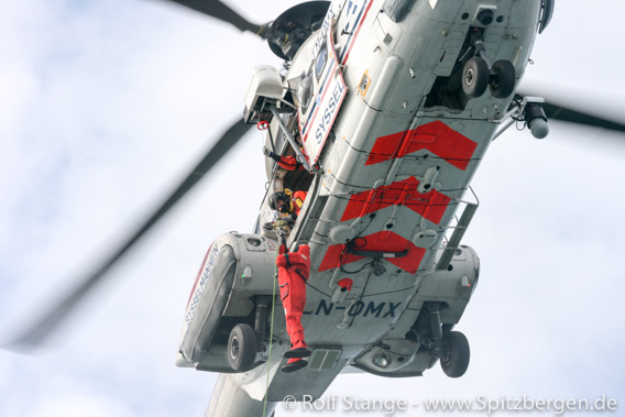
SAR helicopter of the Sysselmannen, here seen during an exercise.
But the good news is that all persons seem to be well. The crew of 14 have dressed up in survival suits and gone to the bow area to be picked up by the rescue helicopters. According to the ship owner, all persons are supposed to be well, at least considering the circumstances. Nobody is injured or has been in cold water.
The Northguider appears to have hit the ground on the coast of Nordaustland south of Murchisonfjord. She is now sitting on the ground and listing with 20 degrees but the position seems to be stable so far. The weather – about 18 degrees centigrade below freezing, darkness and strong wind (Beaufort 6) – makes the rescue operations challenging, but there is no reason to believe that the Norwegian SAR professionals are not able to get all crew members off soon.

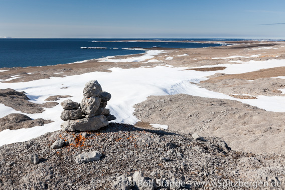
Kalkstranda in Hinlopen Strait, south of Murchisonfjord: the Northguider is supposed to have run aground somewhere here. Conditions there are quite different from the photo now, with darkness, cold and wind.
The coast guard ship KV Barentshav has set course for Hinlopen Strait, but is not expected to arrive there before Saturday. Polarsyssel, the Sysselmannen’s service ship, is not available in Spitsbergen in wintertime.
Update: the SAR central North Norway informs that all 14 persons were taken into the helicopters and are by now taken care of in Longyearbyen. The Northguider is still sitting on the ground, taking in water.
With new Spitsbergen panoramas into the new year
In 2018, again I had plenty of opportunities to shoot arctic panoramas, making these interesting and beautiful (well in some cases, it is interesting or beautiful) easily accessible for everybody. Physically, most of them are pretty much inaccessible for most people. A panorama photo does not physically take you to, say, a mountain top on Prins Karls Forland, but it is the next best thing – it gives you the feeling to be in the middle of the landscape, you can just turn around and enjoy the full view of the arctic landscape.
Over 5 years now, the by far largest digital museum of Spitsbergen (Svalbard) has thus come into existance. And it keeps growing. It takes quite some time and effort to turn the 18 RAW files (35, in some cases) into one panorama and to make that part of a dedicated little website or even to turn many panoramas into one virtual tour, such as the school / kindergarten in Pyramiden. In many cases it has taken years for material to progress on the list to the point where it actually appears on the website.

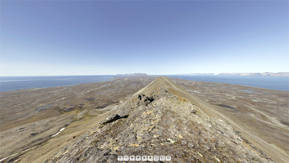
New Spitsbergen panoramas: the round view from Persiskammen, in the southern part of Prins Karls Forland, is just one out of many
(this here is just a screenshot without panorama function).
Here is a choice of new Spitsbergen panoramas that we have made during the last couple of months and weeks – a little Christmas-/New Years’s present for the Spitsbergen community:
- Pyramiden: School / Kindergarten. In October the whole collection of Pyramiden panoramas had moved to a dedicated little map so you can find your way around as you take a little walk through the old ghost town, possibly visiting a building here and there. And we added some new panoramas, including the school / kindergarten, which is our largest single virtual tour so far – the building has 3 floors! Other new ones include the old mines.
- Barentsburg: also here we did not just add new material, but we sorted the panos on a dedicated map, so you know where you are. New panoramas include the brewery, Lenin, the chapel, …
- And while we were at it, of course also Ny-Ålesund had to get its own map to make the whole thing proper. And also here we took the opportunity to add some new panoramas, including Amundsen, the Kongsfjordbutikken, the museum, the Green House, the airshipmast, …
- Let’s get out of the settlements and into the wilderness. Murraypynten is a point on Prins Karls Forland with some fine views.
- Another one on Prins Karls Forland. Nesungen is on the outer side of the island, which is exposed and rarely visited.
- Last but definitely not least from Prins Karls Forland. The view on Persiskammen, this lonesome mountain in the south of the island, is just stunning!
- Elfenbeinbreen in Agardhdalen, not far from the east coast.
- Buchholzbukta is not far from Heleysund, as far east on the main island of Spitsbergen as you will get.
- Polhem in Mosselbukta was Nordenskiöld’s base during his 1872-73 wintering.
- Foxfonna is a little ice cap close to mine 7. Amazing winter views in central Nordenskiöld Land.
- Rijpsburg on Bohemanflya is not just the site where the first commercial coal mining took place in Spitsbergen. It is also a beautiful place.
- Finally back again to civilisation. The taubanesentrale (coal cableway centre) is one of Longyearbyen’s eye catchers. Normally it is closed, but here and now … – welcome in!
- One of Spitsbergen’s most difficult-to-get-to places is the famous Global Seed Vault). Once again: welcome in!
Enjoy – and happy new year!
News-Listing live generated at 2025/May/09 at 04:34:00 Uhr (GMT+1)


