


-
current
recommendations- Liefdefjord
New page dedicated to one of Spitsbergen's most beautiful fjords. Background information and many photos.

- New Spitsbergen guidebook
The new edition of my Spitsbergen guidebook is out and available now!
- Liefdefjord
New page dedicated to one of Spitsbergen's most beautiful fjords. Background information and many photos.
-
weather information

| Guidebook: Spitsbergen-Svalbard |
Home → * News and Stories → Italian lost and found
Italian lost and found
After the search after a sailing boat last week, SAR (search and rescue) forces from Sysselmannen and Red Cross were, only a few days later, again out on a major mission. On Saturday afternoon at 16.20 hours, the local hospital in Longyearbyen received a call from an Italian person who was stuck on a steep slope and not able to move. The man said that he could see the airport, without giving further details about his position. Next to lack of local knowledge, language difficulties may have come in here. He finished the conversation without leaving his name or contact details, so it was not possible to contact him again later.
Hence, SAR forces had to move out in darkness and strong winds. The Red Cross searched Platåberget, which is situated near the airport, with about 30 people. Finally, a light signal was seen on a steep slope above the sea on Fuglefjella, between Bjørndalen and Litle Bjørndalen. Strong winds prevented SAR forces from reaching the area by helicopter, so the Red Cross had to walk a longer distance to get to the site. Shortly after 5 a.m. the man was finally rescued; he had spent at least about 13 hours in his position. All involved got back to Longyearbyen thereafter in good condition.
The incident shows how important it is to have at least basic local knowledge and means of orientation as well as the ability to make a proper emergency call if worst comes to worst. Next to some knowledge of a language used locally, or at least a contact who can provide that, this involves the correct local emergency contacts (the Sysselmannen), name and phone number. The man was in very steep terrain, in darkness, strong wind and without local knowledge and orientation. The incident provides a negative example in several ways.
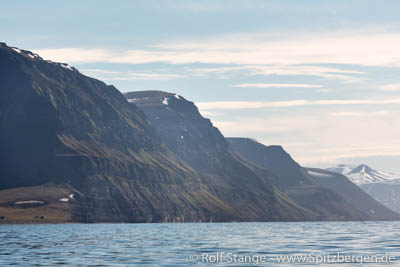
The steep slope of Fuglefjella between Bjørndalen and Litle Grumantdalen on a nice summer day, where an Italian tourist was rescued early Sunday morning in darkness and wind.
Source: Svalbardposten
BOOKS, CALENDAR, POSTCARDS AND MORE
This and other publishing products of the Spitsbergen publishing house in the Spitsbergen-Shop.
-

Norwegens arktischer Norden (1): Spitzbergen
Photobook: Norway's arctic islands. The text in this book is German. [shop url="https://shop.spitzbergen.de/en/polar-books/70-norwegens-arktischer-norden-1-aerial-arctic-9783937903262.html"] ← BackOrder now -
Norwegens arktischer Norden (2): Aerial Arctic
Lofoten, Jan Mayen and Spitsbergen from the air - Photobook: Norway's arctic islands. The text in this book is German, but there is very little text, so I am sure that you will enjoy it regardless which languages you read (or not).Order now -
Poster “Svalbardhytter”
The poster "Svalbardhytter" (70 x 100 cm) visualizes the diversity of Spitsbergen's huts in a range of arctic landscapes.Order now -
Book “Svalbardhytter”
The companion book for the Svalbardhytter poster. The poster visualises the diversity of Spitsbergen‘s huts and their stories in a range of Arctic landscapes. The book tells the stories of the huts in three languages.Order now -
Spitsbergen – Svalbard. The complete guidebook
Comprehensive guidebook about Spitsbergen. Background (wildlife, plants, geology, history etc.), practical information including travelling seasons, how to travel, description of settlements, routes and regions.Order now -
Rocks and Ice. Landscapes of the North
A geographical traveling accompaniment to Spitsbergen and East Greenland (68-74°N). This is the English edition of the German book "Steine und Eis".Order now -
East Greenland in Winter
Join an exciting journey with dog, skis and tent through the wintery wastes of East Greenland! We were five guys and a dog when we started in Ittoqqortoormiit, the northernmost one of two settlements on Greenland’s east coast.Order now -
Postcard set Spitsbergen (Svalbard)
12 Spitsbergen postcards in a beautifully designed tray. Individually numbered limited edition!Order now -
Limited edition postcard set Antarctica
12 postcards which come in a beautifully designed tray. Beautiful images from South Georgia across Antarctica from the Antarctic Peninsula to the Ross Sea and up to Macquarie Island and Campbell Island.Order now
last modification: 2017-09-24 ·
copyright: Rolf Stange


-
Books, Calendar, Postcards and more

-


