-
current
recommendations- Liefdefjord
New page dedicated to one of Spitsbergen's most beautiful fjords. Background information and many photos.

- New Spitsbergen guidebook
The new edition of my Spitsbergen guidebook is out and available now!
- Liefdefjord
New page dedicated to one of Spitsbergen's most beautiful fjords. Background information and many photos.
-
weather information

| Guidebook: Spitsbergen-Svalbard |
Home → October, 2013
Monthly Archives: October 2013 − News & Stories
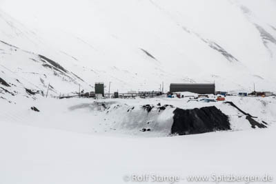
Norwegian coal mining in Spitsbergen currently not profitable
The Norwegian mining company Store Norske is currently not doing well. The company, which is by more than 99 % state-owned, will again present a loss as this year’s result.
Mining in (or near) Longyearbyen is only on an almost symbolic level in mine 7 in Adventdalen. Sveagruva, or Svea Nord to be precise, has given the company good years in the past, but it already feels like a distant past looking at today’s figures. Svea Nord has its best days definitely already behind it. Prepared for mining is a new mine at Lunckefjellet, north of Sveagruva, but the seams there are estimated to last only for 4-5 years of mining and profits are doubtful given current world market prices. Further coal occurrences are explored, for example at Bassen mountain northeast of Longyearbyen, but it is uncertain if a new mine is politically viable.
In 2012, Store Norske finished with a minus of 234 Norwegian Kroner (near 29 million Euro), and 2013 will not be much better. It employs still about 300 people. Earlier in 2013, 70 lost their jobs, not including those in subcontracting companies who depend on Store Norske. This shows how important the company still is for Longyearbyen, where a good 2000 people are living.
Store Norske is using both credits and capital built up during better years to finance investments such as the Lunckefjellet mine. The parliament has made it clear that the company can not expect further public funding. A while ago, Store Norske has bought the majority of shares of the logistics supplier Pole Position. Possibly a hint towards a future beyond coal mining?
The mining in Svea Nord is on the decrease. Lunckefjellet is ready for mining a few miles further north.
Source: NRK
Greenland: ban on uranium mining lifted
Greenland had banned uranium mining politically in 1988. The fear of environmental damage and awareness that an intact environment were the base of the Greenland community were too large.
Potential uranium mining played a major role in the elections for the parliament in Nuuk of March 12, 2013. The new prime minister Aleqa Hammond supports mining. Calls for a wide public debate or a referendum were not heard. After a 5-hour-debate, the parliament of Greenland lifted the ban on October 24. From this day onwards, uranium mining in Greenland is not only a theoretical option, but a future prospect. For example, the Australian-based company Greenland Minerals and Energy Ltd. will have opened some bottle of champagne after the parliament decision. They are sitting on the Kvanefjeld-claim in southwest Greenland, which is believed to be amongst the top 10 sites for rare earths in the world. It also includes uranium, which had accordingly been a political obstacle also for mining rare earths.
Prime minister Hammond was quoted saying “We can’t stand by as unemployment rises and the cost of living goes up, while our economy remains stagnant. We need to overturn the ban now”. Critics claim that there is a real risk of the benefits going to foreign mining companies who might also import cheap labour from Asian countries rather than creating jobs for Greenlanders while leaving Greenlanders mainly with big-scale environmental damage to deal with on the long term.
There has already been mining at a number of sites in Greenland, such as the marble/lead/zinc mine of Maarmoorilik near Uumanaaq, west Greenland. The future will also see uranium mining in Greenland.
Source: NunatsiaqOnline
Spitsbergen with SV Antigua, September 2014: focus on photography
We have added another focus to our Spitsbergen voyage with SV Antigua in September 2014: as we will be travelling during one of the most promising photo-seasons of the year, we will focus on photography with a series of photography workshops. Alexander Lembke will join us again and offer his expertise to enthusiastic amateur (or professional) photographers.
Alex is now university professor for photography at the “Hochschule für Gestaltung” (BTK) in Hamburg. Congratulations!
We will operate the September voyage 2014 with no less than 4 guides to cover the thematic range: hiking, geology, photography. This voyage will be German speaking – refresh your school knowledge of this language and join us! ☺
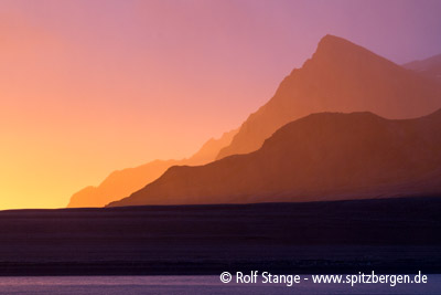
Fantastic evening light in Bellsund, September 2012.
Marine zooplankton more resistant against acidification of ocean water than believed?
The decreasing pH-value of ocean water or in other words the increasing acidification of the global seas is amongst those consequences of global chance that have, so far, received relatively little public attention, but are a major worry for scientists. The world’s oceans are important CO2 sinks, which means they absorb massive amounts of CO2 from the atmosphere. The more CO2 in the atmosphere, the more will be stored in ocean water, which is accordingly becoming more and more acidic.
It is feared as a consequence that marine creatures, especially those plankton species that use carbonate to build up a shell, will suffer severely. This includes many species from single-celled plankton to marine snails. The one thing that many of them have in common is that they are very important for the marine food web. Should the pH-value of the water fall below thresholds that individual species can tolerate, then links of the food chain may break. The extreme consequence would be a collaps of regional food chains and ecosystems. Also seabird colonies and animals including whales, polar bears and seals depend completely on the marine food chain for their survival. There are significant indications that such fears have to be taken seriously.
But there is now also a scientific observation that the marine ecosystem in Spitsbergen may be more resistant against acidification than assumed so far. In Kongsfjord, scientists have carried out a “mecocosm experiement”: nine installations in the fjord where CO2-enriched seawater was added to the natural environment to study the consequences. The result is surprising: the scientists “found almost no direct effects of OA on microzooplankton composition and diversity …” This gives reason to hope that arctic ecosystems may be more resistant against falling pH-levels of ocean water than believed so far.
There is, however, no certainty yet. The study covers only one fjord over a limited period of time. Observations supporting different results are still there and valid. As always, one of the conclusions is: further research is needed …
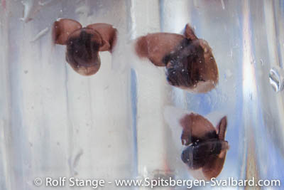
Marine snails in Krossfjord: how resistant are they against increasing acidification of their environment? This is one of the 10000000 dollar questions regarding the future of global ecosystems.
Source: CO2 Science
FatBike Spitsbergen: Bicycling in Svalbard
Bicycling has until now not been much of an issue in Spitsbergen, as the terrain is simply not very suitable for it. This may change to some degree now: “FatBikes” have wheels thick enough to be used on snow unless it is too soft. The law is clear: vehicles may be used only on roads and on frozen, snow-covered ground. New tracks and erosion of vulnerable tundra are accordingly not a problem as long as these regulations are followed.
Since August, there is an operator in Longearbyen called FatBike Spitsbergen. The small company offers FatBike excursions in the vicinity of Longyearbyen. This is an interesting addition to the existing range of organized tours, as it covers a part of the year where offers are otherwise quite thin. The early polar night, which is starting now, is actually an attractive time to visit Svalbard: Longyearbyen is calm and far less crowed with visitors than during the season. Accommodation is accordingly easy to get and comparatively (!) affordable. It is just the range of activities that is less comprehensive than in spring or summer. Now, there is another offer available for those who want to get out.
During the snow-free season, also normal bicycles are actually quite useful on the roads. If you walk, then they are actually quite long. With a bicycle, attractive areas such as Bjørndalen and Adventdalen are suddenly much more accessible.
FatBikes Spitsbergen offers excursions guided in English, Norwegian and German.
Testing a FatBike on the road in Longyearbyen. © Foto: FatBike Spitsbergen.

More: FatBike Spitsbergen
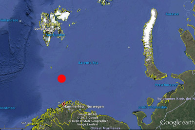
Oil found in the Wisting Central area in the Barents Sea
The exploration well 7324/8-1 in the area Wisting Central has yielded the results Statoil and 3 other involved companies were aiming at. The oil platform Leiv Eiriksson drilled in depths of 373 meters and finally reached upper Triassic strata 542 meters below the sea bottom. Lower and middle Jurassic layers turned out to contain a 50-60 meters thick sequence containing an estimated 10-26 standard cubic meters oil that are believed to be exploitable.
The well will be closed permanently as soon as work has finished. The platform Leiv Eiriksson will then move on to further exploration work further north. The industry has great expectations especially for the Hoop area, that is reaching beyond 74°N and thus into the Spitsbergen treaty area. Exploitation in this area would not only be ecologically risky, but might also be tricky on a political level.
The discovery was the first in the area. Well 7324/8-1 is ca. 310 km north of Hammerfest, less than 200 km southeast of Bear Island (Bjørnøya). The surrounding Barents Sea is biologically very productive and an important area for fish, whales, dolphins and hundreds of thousands of seabirds that breed on Bear Island and the coast of north Norway.
The approximate position of the Wisting Central field is marked red. © Map: Google Maps.
Source: Petro.no
Digital Svalbard map freely available from 2015
It would almost be too good to be true: The Norwegian Kartverket (the mapping authority) has announced that digital maps will stepwise be made available to the public for free use. Maps from mainland Norway will make a start in October 2013. Svalbard is to follow in 2015.
Until now, the policy regarding digital Svalbard maps was very restrictive and has received strong critizism. There is a digi-map for sale (“Svalbard Topo-Explorer”) for more than 1000 NOK, but it is very inaccurate for large parts of Svalbard, and the purchase does not include any rights for use on the internet or in printed publications. So far, the copyright for use in print is astronomically expensive; for this reason, we have so far unfortunately not been able to use this map material in the guidebook Spitsbergen-Svalbard. There is an online version of the digital Svalbard map on the website of the Norwegian Polar Institute, which is very accurate, but it cannot be used offline, for example in GPS receivers in the field or for publications. Now there is hope for a real improvement from 2015.
According to the Kartverket, this step is meant to increase creativity and business use. Reason to smile for publishers and guidebook authors! 🙂
Digital map of Svalbard (screenshot from the website of the Norwegian Polar Institute): free use is announced to be possible from 2015, something that would be highly welcome for users in the field, publishers and digital economies.
Source: Computerworld
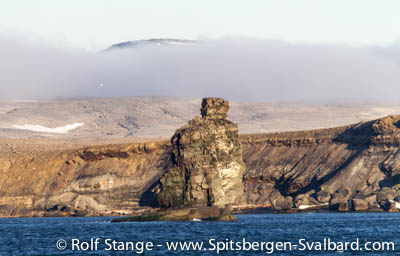
Helicopter base on Bear Island (Bjørnøya)?
There is a growing debate within the Norwegian oil and gas industry and politics about a helicopter base on Bear Island (Bjørnøya), a relevant issue in view of growing activities of the industry in the northern Barents Shelf area, which cannot directly be reached by helicopters from north Norway. To reach these remote areas, all helicopters including search-and-rescue helos need to refuel on Bjørnøya, an operation that takes time and resources which might be crucial in cases of emergency.
Bjørnøya was declared a nature reserve in 2002, which is the strictest protection status an area can get. Excluded is a small area around the weather station in order to keep the activity there away from trouble. But already before the Bjørnøya Nature Reserve was declared, the Norwegian government made clear in a governmental declaration (Stortingsmelding Nr. 9, 1999-2000) that protective legislation might be removed for some areas to establish infrastructure connected to activities of the oil and gas industry. A suitable area was already identified on the north coast of the island, east of the station.
The question of SAR and oil spill facilities becomes more and more important in the light of increasing industrial activity in the area.
Coastal landscape on northeastern Bear Island (Bjørnøya). Strictly protected as nature reserve, but nevertheless possibly the neighbourhood of a helicopter base in the future.
Source: Radio Nordkapp
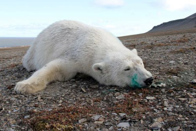
Polar bear dead after anaesthetisation by scientists (II)
In September, a polar bear was found dead on Edgeøya after having been anaesthetisated two days earlier by scientists from the Norwegian Polar Institute. The bear had suffocated, most likely after having changed its position while still under influence of the anesthetics from a safe sideways position (see spitsbergen-svalbard.com news from September). Anaesthetisated polar bears are not further monitored after scientific investigations are finished, so there is always a latent risk of suffocation or predation by other bears.
The case of the dead polar bear from Edgeøya in September is now closed by the Sysselmannen as a legally not relevant incident.
The scientific work on polar bears which involves following them with helicopters and anaesthetisation is carried out in Spitsbergen on a large scale, as it enjoys political support from the Norwegian government. Most bears observed in Spitsbergen by tourists by now carry visible signs of such scientific work, including collars with sattelite trackers, ear marks, numbers or changed behaviour (such bears may at least temporarily react visibly more nervous and afraid on human presence, see spitsbergen-svalbard.com news from October 2012). Both extent and methods of this research are regularly met with critizism.
Has not survived its meeting with scientists: polar bear at Meodden, Edgeøya (© foto: Sysselmannen på Svalbard).
Source: Sysselmannen
World War II ammunition at Adventtoppen
The madness of the Second World War has left its traces even in remote areas as Spitsbergen. The discovery of grenade launcher ammunition on Adventtoppen, on the north side of Adventfjord opposite Longyearbyen, has drawn attention in July 2013 (see spitsbergen-svalbard.com news from July).
Now we know the story behind it. The information is from interviews by Prof. E. Dege in the 1980s and 1990s with Werner Koehl. Koehl was leader of the reconnaissance patrol “Schneehuhn” (“Ptarmigan”) that was on a reconnaissance operation in Spitsbergen in August 1944 with the submarine U-307.
Prof. Dege kindly added the following to the story about the discovery of the ammunition in July (own translation):
“The reconnaissance patrol went up from central Hanaskogdal on 07 August 1944 to the ridge between Adventtopen and Hiorthfjellet and discovered on the ridge a fully developed (but not occupied) position of the (Norwegian) garrison in Longyearbyen. They found sleeping bags, provisions, (pharmaceutical) drugs, and the said grenade launcher ammunition. The ammunition was too heavy for the patrol to carry, so they concealed them under some rocks nearby. After this, the patrol watched the activities in Longyearbyen and Moskushamn for a while from a barack of the abandoned mine Hiorthfjellgruva, situated in an altitude of 600 m on the south slope of Hiorthfjellet, before they went back again to Diabasodden, where they were picked up on 11 August 1944 by U-307.”
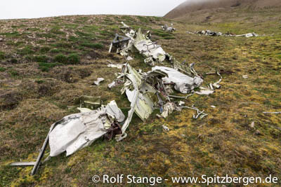
Visible traces of the Second World War in Spitsbergen, harmless in this case: airplane wreck in Hiorthhamn, opposite Longyearbyen.
Source: communication with Prof. E. Dege
News-Listing live generated at 2025/May/02 at 21:53:19 Uhr (GMT+1)


-
Books, Calendar, Postcards and more

-


