-
current
recommendations- Liefdefjord
New page dedicated to one of Spitsbergen's most beautiful fjords. Background information and many photos.

- New Spitsbergen guidebook
The new edition of my Spitsbergen guidebook is out and available now!
- Liefdefjord
New page dedicated to one of Spitsbergen's most beautiful fjords. Background information and many photos.
-
weather information

| Guidebook: Spitsbergen-Svalbard |
Home →
Yearly Archives: 2014 − News & Stories
Raudfjord
Mon
18 Aug
2014
Time for some exercise, which we got while hiking a good 10 kilometres along lagoons and a big lake in a silent valley. Later, the world disappeared largely behind a grey curtain, which wasn’t too bad, some rest was needed by most on board. Having been on watch last night may have played a role here.
Nevertheless, sitting outside on deck around the BBQ, spotting a polar bear family in the fog … again, one of these days!
- gallery anchor link: #gallery_560
Click on thumbnail to open an enlarged version of the specific photo.


The high north
Sun
17 Aug
2014
Actually I thought I shouldn’t write anything. The pictures tell the story, don’t they?
But I can’t really keep my fingers off it. This lovely little bay at North Cape (not the one you are thinking of) was completely unknown and uncharted. It was a masterpiece of navigation by Heinrich to take the Arctica II in there, finding a safe anchorage for the night. And it was even more of a masterpiece to get her (and us) out of there again next morning, after the ice had settled down in the entrance.
Who would have thought 2 weeks ago that we would make it to Sjuøyane, the furthest north up here in the far north? The arctic, here at least, is really arctic this year, with a lot of ice. Out of reach. This is how it should be. But our calculation, to start the trip going south, getting later to the north to give the ice more time to loosen up a bit, was quite right. Perfect timing! It was just the right day for a dash up to Sjuøyane, which presented themselves really the arctic way, with snow and ice-cold wind. The last winter hasn’t really left, the next one is already well on its way. A place forgotten by the summer.
- gallery anchor link: #gallery_558
Click on thumbnail to open an enlarged version of the specific photo.


A free ice cream who can tell me where Nordlysøyane are without a look at the map (the ice cream is to be picked up on Nordlysøyane, just in case). I can tell you that there is a rather curious sub-adult polar bear there.
Northwestern Nordaustland
Sat
16 Aug
2014
Amazing what kind of ideas you can have while walking around between the old buildings in Kinnvika in dense fog: I have to have automats with my books at popular landing sites in Spitsbergen! If they don’t want to sell them on the ships here – some of the companies even pretend their guests don’t read. What do they think of their clients?! – then I have to meet them somewhere else. So I need automated selling points with automatic refill. I could see myself being content with one each at Gravneset in Magdalenefjord and in the harbours of Longyearbyen and Ny Ålesund.
That’s the kind of thoughts that can cross your mind when you are walking around in fog. Crazy, of course, but funny.
We couldn’t see much of the low shorelines around Lady Franklinsund either. A bit of a shame, as you don’t get there too often. It is very shallow and completely uncharted. Heinrich is one of the few skippers who are taking their small boats through there.
All this doesn’t bother you if you are a walrus. Then, almost nothing will bother you. This became pretty clear with this mighty fellow on an ice floe in Lady Franklinfjord.
The names are interesting: Brennevinsfjord, translates as booze bay or something similar. I guess that centuries ago some whalers had a wild party there, but nobody knows for sure. Barren rocks, a wild, rough country. Not the friendly tundra of the west coast, where it is lovely to hike for hours, where you have the feeling to be in a living country. Here, you are a guest for a short while, no more. If you stay too long, like Schröder-Stranz in 1912, the land may take you. Who knows. But anyway, we dare to go ashore in Booze bay for a few hours.
- gallery anchor link: #gallery_556
Click on thumbnail to open an enlarged version of the specific photo.


You usually don’t see tabular icebergs in the Arctic. They just don’t do them here. Only in Antarctica, there they are very common. Nevertheless, we saw one today, not the biggest one, but nice. Probably from the Russian Arctic, there are a few ice shelves there. As a consequence: Russia is Spitsbergen’s Antarctica.
Southwestern Nordaustland
Fri
15 Aug
2014
(Thursday and Friday, 14th and 15th August 2014) – How often do we see glaciers from the boat or from the tundra? Every day. How often do we view down from glaciers to fjord and coast? Exactly.
This trip was meant to be an opportunity to do things that you don’t normally do on ship-based trips here. Even more so than otherwise on the trips that I do. One of the things that you would not normally get to do on a Spitsbergen cruise is a glacier hike. There is this nice little glacier in Augustabukta, they called it Mariebreen in 1868. It is actually part of the ice cap Vegafonna, which again is connected to Austfonna, more than 8400 square kilometres large and Europe’s largest ice cap. Dive into this weird icy world of glaciers for a few hours. Meandering meltwater rivers with blue water, shining white ice under a heavy grey sky that is merging seemlessly into the ice cap on the horizon. A step out of the world of leaving things. There is nothing alive here. Ice and water, some stones, that’s it.
Crossing something has always something fascinating about it. It does not have to be an inland ice of continental scale. A peninsula can be enough. You are dropped off and you see your boat sailing away. That makes you feel a bit like Nansen, who was dropped off at the East Greenland coast in 1888. His choice was simple: reach the west coast of die. The rest is history.
Of course, it isn’t quite like that in the 21st century anymore. In case of any unexpected real difficulties, you grab the radio or the sat phone and ask the boat to return. But still, it is an exciting thing.
21 kilometres of tundra and polar desert, ridges of basalt rocks and fossils older than the hills, frost patterned ground and meltwater rivers. A day long enough to really get lost in this amazing country, mentally, I mean. Listening to the water running in rivers and to the wind (there was more than enough of the latter, to be honest. It was freezing old at times.
- gallery anchor link: #gallery_554
Click on thumbnail to open an enlarged version of the specific photo.


At the end of the hike, on the shore of Palanderbukta, there was an old trapper hut, where the wind was blowing through holes that were doors and windows many years ago. Weird story. The two trappers who built the hut probably managed to blow themselves up in January 1934. One of them was hit while he was in for serious business in the outhouse. Not a nice place to die. He was found there months later, still sitting, frozen solid. Weird story. They never found out in details what had really happened.
But for us, the day had a very happy end when we came back to the boat and salmon was almost ready 🙂
Barentsøya
Wed
13 Aug
2014
The southeastern islands are really polar bear country. Bears everywhere, it can be difficult to find a place where you can go for a walk. In Freemansund, everything is occupied by these creamy-white polar sheep. And of course, you might ask, why. The question „what are they doing here? There isn’t anything they can eat?“ is one that I hear about 100 times every day. One easy, but nevertheless true, answer is because it is their home, after all. They are living here. They want to be here. They could go somewhere else, if they wanted to, including the pack ice in the north. They would be there within a few days, but they stay here.
But of course it remains a valid question what they find to eat. Some bears here are quite fat, the blubber has to come from somewhere.
I’d quite like to find out, so I have developed a habit that might help me to learn more about it: I have started to take pictures of polar bear shit. Every time I find some droppings on the tundra, I grab the camera and press the button. Unlikely that this collection turns into a photo book some day. You may find it strange that I walk around here photographing shit. As you wish, I don’t care. I find it interesting. You just have to take a close look. This morning, I found smashed reindeer bones in one pile of shit. Teeth in another, also reindeer. Many times, I see feathers, and vegetation remains are very common. Here you are, that’s an answer getting shape, isn’t it? So I am more than happy to keep going with this shit photography business, whenever the opportunity arises.
Change of subject (anyone still with me?). Today has been the coldest day of the summer up here so far, just 2 or 3 degrees. Quite cold, when you include the fresh easterly breeze. Where is the summer? The flowers loose their colours, the leaves of the polar willow change their colours on large areas now.
- gallery anchor link: #gallery_552
Click on thumbnail to open an enlarged version of the specific photo.


The tundra over which we are walking is a real whale cemetary. Several thousands of years ago, when this used to be the coast, dozens of whale carcasses must have drifted ashore here.
Ryke Yseøyane
Tue
12 Aug
2014
Some places have got fascinating names, they keep just sounding in my mind, vibrating, generating a drawing power almost like a magnet. Maybe it helps to spend evenings with maps instead of books sometimes, to get a perspective on the remoteness of some of these places. Or to hike around in Spitsbergen. It takes four days on foot from Longyearbyen to the east coast. So that is the end of the world. From this end of the world, you can see Edgeøya on the horizon. Sitting there, on a moraine hill on the east coast, with tired legs, looking across Storfjord to Edgeøya, makes you dream of getting there one day. You know it will probably never be in reach, but who knows. Then, it means something different to you, it is something very special to get there one day, compared to just being there suddenly, another place on a cruise where you are suddenly to go and see some animals, without ever having heard the name of the place before, without remembering it beyond the evening of the same day. Anyway … I am drifting away. So, imagine the east coast is the end of your world at some stage, and from there, you can see Edgeøya. And you know, there are still some small, very lonely islands behind it. Ryke Yseøyane, the Ryke Yse Islands.
In short words, they are far away from everything.
Dark, bleak basalt islands, rough and wild. And as mentioned, this name: Ryke Yse! Nobody could think of a name like that. Ryke Yse was probably a Dutch whaling captain, 17th century. Thank God his name was not, say, Fred Clever. I don’t think I would be interested in going to the Fred Clever Islands. But so … wild place. Only two dared to winter there. Only one survived. A rough landscape. Edgy dolerite rock, falling apart into sharp blocks, covered with lichens, steep cliffs, a home for Black guillemots.
And we even made it on 2 out of these 3 little islands!
- gallery anchor link: #gallery_550
Click on thumbnail to open an enlarged version of the specific photo.


Time to get on, then. Many kilometres of glacier front on our port side during the later afternoon. A wall of marble, all shades of blue and grey you can think of, sea, ice, sky. Hard to believe this is the same island that has such a colourful, friendly tundra on the other side. But well, it is beyond the end of the world. What do you expect.
Edgeøya
Mon
11 Aug
2014
(Sunday and Monday, 10th and 11th August 2014) – Time is flying. It feels as if I have not written anything in a week, but has been 2 days only. But these were quite busy.
Going ashore on »unknown« islands is one of the greatest pleasures of a polar traveller. Amazing how much you will almost always find, especially on those small islands around southern Edgeøya. Hunters have been there for centuries, they have left their traces and sometimes their own remains in the now autumn-coloured tundra.
Southern Edgeøya was the main area of the polar bear hunters decades ago. The backyard of the polar bear king’s palace is now occupied by walrusses. Their curiousity equals ours. Man and beast – who is more excited about the other one?
A walrus was playing a minor, but important rule then on Halvmåneøya. Some happy polar bears were the focus of the attention of some happy humans. No zoo could arrange a more impressive feeding event. And this is not a zoo, this is the real thing. Without luck, you won’t see anything. With luck, everything is possible.
- gallery anchor link: #gallery_548
Click on thumbnail to open an enlarged version of the specific photo.


A visit to the legendary trapper station Bjørneborg completes an exciting visit to the realm of polar bears, walrusses and their human stalkers in the old adventurous days. Good stories. Good they came to an absolute end in 1973.
Kvalvågen
Sat
9 Aug
2014
Leaving our anchorage under sails and sun, passing large icebergs, that meant starting the day in a lovely way.
I wasn’t quite sure if we were able to keep it like that; this gentle swell on the rocky, exposed east coast might be trouble. But going there and having a look is always the best thing to do. It turned out to be surprisingly easy.
An excursion to Jurassic Park, or rather Cretaceous Park. I have heard that there is even a report about the famous dinosaur tracks in the latest edition of Svalbardposten, from last week. Good timing. Now we want to see the real thing. Big footprints of big, evil, meat-eating dinosaurs, who left the marks of their big, sharp claws in the muddy sand more than 100 million years ago (sometimes, exctinction of species isn’t such a bad thing at all …). There are quite a few of these tracks here, but most of them quite weathered. But one or two are still well visible. It took us some time, but we found them in the end.
But this rocky coast, the lovely flowers and the view over the wild east coast would be worth a day alone! You have to take such an opportunity. How often do you get to a place like this, on such a sunny day? Even on a calm day like today, the surf on the shallows is quite impressive.
And the perspective from 250 metres doesn’t leave anything to be desired. Also the sportive aspect was finally satisfied. Viewing over almost the whole of Storfjord, to Edgeøya and the east coast far to the south, and Norwegian chocolate. What a place, what a life!
- gallery anchor link: #gallery_546
Click on thumbnail to open an enlarged version of the specific photo.


Later, time to relax while we cross Storfjord over to Edgeøya. The siesta is interrupted by some Finwhales and dolphins.
Isbukta
Fri
8 Aug
2014
Sometimes, 200 metres are more than enough to have the world below you. And if this world is Sørkapp Land with its wide glaciers and some of Spitsbergen’s finest mountains, under a blue sky and a bright sun, then it is one of life’s better moments.
Stellingfjellet has one of the archipelago’s largest guillemot colonies, high up on the cliffs. Ten thousands of them. It would rival famous Alkefjellet in Hinlopen Strait, but the first floor is uninhabited and the visitor’s lounge a bit more distant.
High surf on the beach. A polar bear is roaming around, looking for birds that have fallen down from the colony. Our first bear.
There is one glacier after the other on the east coast, separated by steep, dark cliffs. Inhospitable and wild.
- gallery anchor link: #gallery_544
Click on thumbnail to open an enlarged version of the specific photo.


We find a silent anchorage in a bay that does not even exist. Virgin land, which appeared just very recently under the retreating glaciers. We don’t miss the change to explore it a bit just before midnight, finding ammonites and polar bear tracks with surprisingly large icebergs in beautiful evening light in the background.
Hornsund, Südkap
Thu
7 Aug
2014
Last night, we sailed the west coast down to Hyttevika, just north of Hornsund. A calm anchorage, what else would you want?
Trapper legends like Wanny Woldstad and Odd Ivar Ruud all had their good reasons to make Hyttevika their home for their arctic hunter lives. On a nice day like today, it is an arctic paradise. A cosy hut, hidden behind quarzite rocks. Reindeer on mossy tundra, screaming Little auks high up on the slopes.
Hornsund, however, was not in good shape today. Windy and mostly grey and rainy. Not a place to be today. So we left quickly from there, hoping for more luck on the outer coast. Still, windy. But our fearless skipper Heinrich took Arctica II through Mesund, between the islands off the southern tip of Spitsbergen, saving us from many uncomfortable miles.
A calm anchorage was all we wanted at the end of the day, and we found it in Isbukta. Midnight reindeer stew rounded the day nicely off.
Bellsund
Wed
6 Aug
2014
I’m afraid that I will probably write more again than anyone will want to read. Well, that’s life. Not my problem, anyway, I am only writing it, I don’t have to read it.
A lovely glacier in sunshine as „early“ morning exercise.
Then a trip back into the past. A tour that I already wanted to do in 2011, but something was in the way back then, a polar bear on the beach, or bad weather, or both, I don’t remember. Back then, there were people with me who are now again on board. Another good reason to get back to this idea to hike from Van Mijenfjord to Van Keulenfjord. 12 kilometres in some hidden valleys of Nathorst Land.
For me, a trip back into my own past, as we went through these valleys ages ago on a ski trip. Back then, we mistreated every one of the numerous small waterfalls in these valleys with ice climbing equipment, roping ourselves and all our stuff up rather than walking around the waterfalls on the even slopes. That would have been boring. So the whole thing took 3 days for a few kilometers. Today, we hope to be a bit faster.
And a trip back into the very distant past of Earth history. Moonlike landscape of rocks from the middle ages of our planet. Weird impressions. Colours most ship-based travelers wouldn’t know from Spitsbergen. And then these beautiful waterfalls carved into even older rocks. Now, in August, we wouldn’t get very far there with ice screws.
- gallery anchor link: #gallery_542
Click on thumbnail to open an enlarged version of the specific photo.


If I finish now, maybe some of you have read the way through it. So. End of story for the moment. Thank you for reading this far.
Alkhornet, Reiniusøyane
Tue
5 Aug
2014
It is nice when Norwegian authorities do something useful, just for the change, such as charting the fjords here. Until recently we thought that you can walk rather than sail in the innermost part of Trygghamna. Now it has suddenly turned into a lovely anchorage for a calm night with a brilliant glacier view, which could even get us out for a short midnight walk at a time when most of us 12 here on board were actually already sleeping.
Alkhornet is a classic. Spitsbergen in a nutshale, you could sell it like this. Maybe something for tourists from the far east, who never have enough time. Direct flight to Longyearbyen, speed boat to Trygghamna, 2 hours walk at Alkhornet. And you have seen it all. Really! Well, almost. That’s why we keep going now for another 16 days. I am sure we will find something we haven’t seen this morning.
But the tundra at Alkhornet is a green meadow. The bird cliff, high up, brings fertilizer and background music. Down on the tundra, the reindeer are doing what they are good at: eating. Quite successfully so, as the diameter of the big ones makes unmistakably clear. Spitsbergen’s nicest and strongest reindeer, and the cutest calves, treating their mothers’ bellies with a lot of gusto to squeeze every drop of the rich milk out that the cows have produced from the tundra.
Another Nøis hut at Alkhornet, built in 1920, now just a ruin. It was used during 5 winters by Ewald Schmutzler from Thuringia between 1923 and 1941. Old stories.
Where has the wind gone? But rather a calm afternoon with some engine noise than throwing up under sails.
- gallery anchor link: #gallery_540
Click on thumbnail to open an enlarged version of the specific photo.


A late evening walk on some tiny islands in northern Bellsund rounds the day nicely off. Wild coastal rocks, beaten by waves most of the time, rarely seen from close distance, but nice and calm tonight.
Longyearbyen, Isfjord
Mon
4 Aug
2014
Final preparations. Packing again, trying not to forget anything. From suncreme (always being optimistic!) to the ever-growing pile of technical gear to a good selection of warm and weatherproof clothing. Some last shopping, emailing and so on.
Arctica II, a 60 feet yacht, is ready to sail. A lot of space inside for a yacht, everything will fall into place somehow. Even if not everybody believes it, initially at least.
„Advanced Spitsbergen“ is starting. Here we go ☺ !
We take our time to stow everything away, and Heinrich, skipper and boat owner, is taking care of some remaining small things. We get an updated ice chart and pizza for tonight. The ice is still dense around the north coast of Nordaustland. Unusual, compared to the last few years, but wonderful. „Inaccessible“ sounds good, but it means that you can actually not alway get everywhere. That’s what it means. Sometimes people love to go to inaccessible places and then they are surprised that it is not always possible. Surprise, surprise.
Maybe the ice will loosen up a little bit over the days to come. To give it some time to do so, we decide to start southwards, getting to the far north a little bit later. After dinner, we are starting, sailing to Trygghamna to anchor there for the night, maybe a little hike tomorrow, before we set course for Bellsund.
- gallery anchor link: #gallery_538
Click on thumbnail to open an enlarged version of the specific photo.


On the icy road again ☺
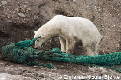
Again polar bear caught in fishing net
In July, a polar bear was seen on the north coast of Spitsbergen with a plastic fishing net around its neck. The bear was found again later, it could then be anesthetized and freed from the potentially deadly debris.
Not much later, another polar bear, again a female, was found entangled in a fishing net. In this case, the bar had a small transmitter in its ear, placed there by scientists to track migration movements. The net was entangled around the transmitter.
The bear was found in Sorgfjord by volunteers of the governor’s beach cleanup trip. Experts of the Norwegian Polar Institute (NPI) were flown in by helicopter to tranquilize the bear, but just before the NPI biologist fired, the transmitter fell off together with the net and the polar bear was free of the its burden. There were no signs of injury, and the bear seems to be fine.
Norwegian fishery is now facing criticism for the amount of dangerous fishing nets and other debris found in the north Atlantic and shorelines there. Fishing vessels are obliged to report loss of fishing gear at sea, and the fishery authority (Fiskeridirektorat) has, since 1980, the responsibility to retrieve lost nets and other dangerous debris if possible. Since 1980, more than 17,000 nets have been retrieved. The number of fishing nets found on beaches in Spitsbergen and elsewhere indicates, however, that the numbers of nets actual lost must be higher. Since 2008, damaged nets can be discharged in Norwegian ports free of charge.
This female polar bear had got a transmitter in her ear by scientists, which got entangled in a heavy fishing net. © Christian Nicolai Bjørke.
Source: Svalbardposten
SAR mission because of problems with satellite communication
Many providers of satellite-based communication services had technical problems in late July for several days. This led, amongst others, to delays of my arctic blog on this website.
Other consequences were more serious. Worldwide, ships were not able to download updated weather information. In Spitsbergen, a French sailing yacht was missing for several days; the families of the crew had not received messages as agreed for 6 days. The Sysselmannen sent a plane out to search for the yacht, which was found near Smeerenburg with everybody on board in good condition.
The technical problems were deep in the complex system, far out of reach of and unforeseeable for the individual user. By now, the problems seem to be solved.
This communication device is almost undestructable, but unfortunately not mobile. Pyramiden, near the port.

Source: Sysselmannen
News-Listing live generated at 2025/May/03 at 12:42:56 Uhr (GMT+1)


-
Books, Calendar, Postcards and more

-


