-
current
recommendations- Liefdefjord
New page dedicated to one of Spitsbergen's most beautiful fjords. Background information and many photos.

- New Spitsbergen guidebook
The new edition of my Spitsbergen guidebook is out and available now!
- Liefdefjord
New page dedicated to one of Spitsbergen's most beautiful fjords. Background information and many photos.
-
weather information

| Guidebook: Spitsbergen-Svalbard |
Home →
Yearly Archives: 2014 − News & Stories
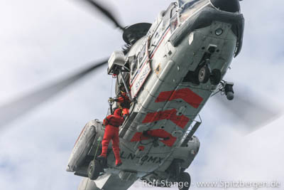
26 ended their Easter holidays in the SAR helicopter in Spitsbergen
Easter is high season for the outdoors in Scandinavia, and the same is true for Search and Rescue (SAR) forces – depending on the weather. This year, the weather was not very stable during the Easter weekend, with lots of snowfall and some strong winds, which in some regions reached gale force.
In the end, the local SAR forces had to airlift 26 persons out from their Easter trips. This includes a group of 19 on Akademikarbreen (not 16 as mentioned earlier), who had got stuck in bad weather, with 2 tents already destroyed in gusts. They got their ride back to Longyearbyen on Saturday. The same day, a person was evacuated from Petuniabukta (near Pyramiden) after a snow mobile collision. Yes, such a thing can happen, even in the wide-open wilderness of a frozen fjord. Especially in strong winds with poor visibility.
Beyond this, one person had to be airlifted from Kapp Linné and another one from the research vessel Lance, both with injuries.
All persons are well, there were no serious injuries.
Happy Eastern …
The SAR helicopter in Spitsbergen during an exercise. 26 went back to Longyearbyen with it during the last weekend.
Source: Sysselmannen
Yet another SAR operation in Spitsbergen: 16 skiers stuck in storm on Akademikarbreen
Eastern is high season for the outdoors in the whole of Scandinavia, but unfortunately also high season for SAR (search and rescue) operations. On Easter Sunday, again an emergency beacon has been activated in Spitsbergen. A group of 16 skiers, including 3 guides, is currently stuck in a storm on Akademikarbreen, in central parts of eastern Spitsbergen, between Newtontoppen and Storfjord. With a satellite phone they informed the Sysselmannen that 2 tents are already destroyed in the storm.
Next to the SAR helicopters, which are currently on the way, the SAR forces are preparing a snow mobile expedition, as it is uncertain whether the helicopters can land in the prevailing bad weather.
Currently, there is no further information about the situation of the group available.
Akademikarbreen in strong winds. Currently, 16 skiers are stuck there in a storm, waiting for rescue forces.
Source: Sysselmannen
Research vessel Lance breaks ice in Dicksonfjord
In the north and east, the drifting sea ice is now more and more closing around Spitsbergen’s coast, but the fjords remain largely ice-free this year. Even fjords that usually freeze over quite reliably, such as Tempelfjord, Billefjord, Dicksonfjord, Ekmanfjord (all branches of Isfjord) as well as Wijdefjord and Van Mijenfjord are far more open than they usually are, much to the regret of those who are enjoying the current ski, dog sledge and snow mobile season – and, more importantly, the wildlife, who needs the ice to give birth to their offspring, such as Ringed seals, or to find food, as the polar bear does.
At least, some fjords are frozen in their innermost parts. Dicksonfjord had an ice cover that came closer to normal standards than in the case of most other fjords.
Recently, from 8 to 10 April, the research vessel Lance broke a lead of several kilometres into the fast ice of Dicksonfjord. This was done as part of a field course in sea ice, originally scheduled to take place in Hornsund, but as ice conditions there did not develop suitably, UNIS applied for permission to break a lead of “several ship’s lengths” into Dicksonfjord.
The result is an opening several kilometres long. At the innermost position, the ice thickness was a mere 35 centimetres. Further out, it was even less. It can accordingly not be expected that the ice freezes solid again during the current season. It seems rather likely that the long crack may decrease the stability of the whole fjord ice, potentially contributing to an earlier break-up of the ice in Dicksonfjord.
The lead broken by Lance is met with criticism from several sides. Amongst others, Harald Soleim, a Norwegian trapper who has lived in Dicksonfjord for many years, is less than amused. During spring, he uses the fjord ice to travel within his hunting area by snow mobile. He was not even informed about the lead broken by Lance and described the unexpected opening as “directly life dangerous”. UNIS regrets not having informed Soleim in advance. If breaking up fjord ice in times of low ice cover, at the cost of wildlife and humans, is justified for a scientific field course, may be disputed. It is doubtful that permission had been given if standards for scientific operations were equally strict as for touristic activities.
Fjord ice in Tempelfjord: much less than normal in terms of area and thickness. It is controversial for which purpose the ice may be broken when there is already less than needed anyway.
Man fell 6 metres into glacier crevasse on Conwayjøkulen
The similarity to the next to last headline is no coincidence: again, a skier fell down a crevasse on a glacier in Spitsbergen. And again, it went well in the end.
A group of five tourists led by one guide was on the way back from a trip to Newtontoppen, Spitsbergen’s highest mountain. In the area of Conwayjøkulen, northeast of Billefjord, the group got into crevassed area. At the time (Thursday, 16 April) the weather was bad in the area, with strong winds and drifting snow and visibility accordingly poor. The six skiers were roped up into two groups of three persons each, when the guide, leading the first group, well down into a crevasse. His two followers could, however, stop his fall after 6 metres. The second team approached the crevasse and finally managed to retrieve the emergency beacon, which the guide had with him.
Due to the poor visibility on the ground, the rescue helicopter was not able to land, despite several attempts. Rescue forces in Longyearbyen prepared a ski expedition, and the helicopter prepared to winch the six persons all up individually, when the weather improved slightly, allowing the helicopter to land. Meanwhile, the five skiers on the ground had managed to get their guide up from the crevasse. He had suffered light shoulder injuries, but was otherwise unhurt.
All six and their dog could then board the helicopter and return to Longyearbyen.
The exact position of the crevasse has not been published. The wide glacier areas of Lomonossovfonna are generally thought to have few crevasses only. It is possible that the group had ended up somewhere they would not have gone in better visibility. It is not known if the crevasse had been visible under better conditions.
Glacier landscape in the area of Lomonossovfonna, not far from Conwayjøkulen, where a man fell 6 metres into a crevasse on Thursday.
Sources: Sysselmannen, Svalbardposten
East Svalbard Nature Reserves: new regulations in force on 01 May 2014
The highly controversial process of new regulations in the large nature reserves in East Svalbard is now largely coming to an end: the new law is coming in force on 01st May 2014. The quarrel has been open and partly heated since at least 2007.
The result is largely following the Sysselmannen’s proposal from January 2013. It remains, in the eyes of the present author, valid and true that the expertise behind the new regulations is, in large parts, weak or not existent. Nevertheless, most of those traveling the areas in question should at least largely find themselves able to get used to the new situation (and if not, they will have to, anyway) without too drastic changes. Regarding some potentially important details, it remains to see how it will work in practice. This concerns access to the new, so-called scientific reference areas.
The important changes are the following (partly quoted from Spitsbergen-Svalbard.com news, January 2013. Updated and added to as needed).
Six partly new zones will be determined in the large Nature Reserves in East Svalbard. Some of them are large, others restricted to single locations. Different regulations apply to these zones (see map below):
Zone A (yellow): “Scientific reference areas”. Anyone who wants to travel there needs to notify the Sysselmannen at least 4 weeks in advance. The Sysselmannen can require changes of plans or stop them altogether. The result could potentially still come close to a complete closure of the areas in question, which are large, although mostly (but not completely) irrelevant for tourism. The scientific need for and value of such reference areas remains very controversial, no solid arguments that support such a need or value beyond general, rather diffuse remarks of general prevention, have been put forward. This did not keep DN and other interested parties from declaring that such areas were necessary. By the way, an obligation to apply for permission to travel in the East Svalbard Nature Reserves – which cover the proposed reference areas and far more – is already in force and has been so for many years. Time will have to show what the new regulations will really bring. Anything is possible from a little bit more paperwork before the trip to a factual closure of large areas.
Zone B (orange): No admission between May 15 and August 15. This means in practice a closure of parts of Lågøya and all of Tusenøyane for most of the relevant season. This is the only “detail” where the map below needs to be updated: the closed area does not include the whole island, but the west coast and the northern tip. The latter is the only part of the island that is regularly visited by tourists. A similar regulation is already in force for the bird reserves, but these are restricted to smaller areas and locations, mostly the actual breeding colonies on smaller islands, rather than larger islands and whole island groups.
Zone C (green dots): site-specific regulations are to apply. This is a procedure which is getting increasingly common for polar tourism, for example in Antarctica. The site-specific rules are to be compiled by the tourism industry (represented by AECO) under the Sysselmannen’s supervision. A lot of work on these site-specific regulations has already been done. In the east Svalbard nature reserves, there are 4 relevant locations: Polarstarodden (Storøya), Andréeneset and Kræmerpynten (Kvitøya), Dolerittneset (“Kapp Lee”) and Andréetangen (Edgeøya).
Zone D (red dots): smaller areas around cultural heritage sites that are closed completely year round. In force since 2010.
Zone E (red): This is Kong Karls Land. No admission around the year. Has already been in force since for many years.
Additionally, it has been decided that ships sailing in the east Svalbard nature reserves may not carry more than 200 passengers. Grey water and toilet waters may not be discharged within 500 metres off shore and not at all in Rijpfjord, a site for long-term oceanographic studies. Together with the ban on heavy fuel on board ships traveling inside the nature reserves, which has already been in force for some time, these parts of the new regulations make a lot of sense from a conservation perspective.

This map is from the Sysselmannen’s proposal from January 2013 and is used here for practical reasons. The only details that needs some updating is Lågøya, which is not completely closed (15 May-15 August), but only along the west coast and northern tip (Purchasneset), indicated by the red line on the map. The official maps as enclosed with the new law text can be accessed in the Norwegian online law library
Click here for a larger version of this map.
Source: Press release of the Norwegian government: east Svalbard Nature Reserves .
Here you can read the complete law (Norwegian), including maps.
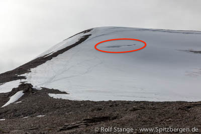
Man fell 25 metres into glacier crevasse on Nordenskiöldfjellet
On Sunday, a skier fell 25 metres down into a crevasse in a glacier on Nordenskiöldfjellet near Longyearbyen. With a lot of luck and swift reaction by the local SAR forces, the man could be rescued essentially without injuries.
The mountain Nordenskiöldfjellet, 1050 metres high, is the southern, higher part of Platåberget and a popular destination for sportive outings from Longyearbyen. The crevasses in the higher, steeper part of the glacier are not unknown. Common routes lead either over parts of the glacier generally assumed to be safe (in a distance of the crevasse in question) or over rocky ridges at either side to the glacier. The latter option is difficult or impracticable in winter, when the rocks, which include some steeper steps, are frozen over with ice.
The skier was in a group of altogether 9 persons who were on the way down from the summit. On the way, the 9 had split up into 2 groups. Once the man, who is in the mid twenties, had fallen into the crevasses, his comrades did not dare to move anywhere, but alarmed the Sysselmannen. Rescue forces of Sysselmannen and Red Cross where soon on the scene with 2 helicopters and after about 2 hours in total the man was in safety again, luckily without any injuries despite a falling distance of 25 metres. It can be assumed that the crevasse was not vertical, which would not be uncommon for a crevasse near the steep contact between ice and rocks at the higher end of a glacier.
The position of the crevasse is given as N78 10.95 E15 26.55 by the Sysselmannen, which is in accordance with the crevasse marked in the photo below. The photo was taken on July 19, 2009 and shows the glacier with less snow cover than currently. At the time of the accident on last Sunday, the crevasse was covered with snow and accordingly invisible at the surface.
Glacier at Nordenskiöldfjellet (archive image, July 2009). The crevasses near the upper end are partly visible. On Sunday, a skier fell 25 metres deep into a crevasse in this area.
Source: Feltlogg Sysselmannen
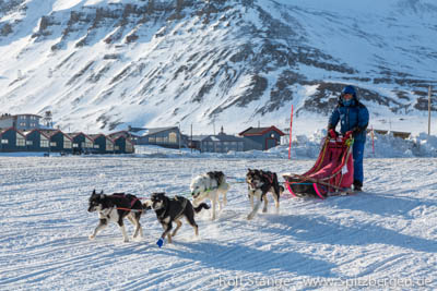
Trappers Trail 2014: Spitsbergen’s largest dog sled race
Impressions from the Trappers Trail 2014, Spitsbergen’s largest dog sled race. Since 2009, the Trappers Trail is an annual event. The route is in toal 75 kilometres long and takes the teams from Longyearbyen via Todalen and Bødalen to Kapp Laila on the first day, where the teams, organizers and visitors enjoy a memorable evening with bonfire, oven-heated tents and a grand view over Isfjord. The second day takes the teams through Fardalen and up to Longyearbreen. The slope up to the pass to the glacier is the toughest part of the route, which is, altogether, well within reason for reasonably well trained teams.
There are several disciplines, depending on the number of dogs per team and the kind of sledge. “Ski and pulk” is a group on its own. This year, “Longyearbyen Hundeklubb” has announced a record-breaking number of participants: 23 teams with 38 mushers and 199 dogs. The winner was not yet certain at the time of writing.
Trappers Trail (gallery)
- gallery anchor link: #gallery_447
Click on thumbnail to open an enlarged version of the specific photo.


Trappers Trail: Spitsbergen’s biggest dog sledge event
This weekend (April 05/06) it’s time again for Spitsbergen’s biggest dog sledge event, the famous Trappers Trail race. This time, records have been broken before the race even started: No less than 22 teams with 38 mushers and 199 dogs have signed in to participate. This is an all time record until now. The Trappers Trail race is an annual event since 2009.
As the weather forecast is pretty good – overcast, but little wind – the teams, organisers and visitors are looking forward to a great dog sledge weekend. The route is on Saturday from Longyearbyen via Todalen and Bødalen to Kapp Laila, where Longyearbyen Hundeklubb has got a hut, where the particpants will stay until Sunday. The route back is going through Fardalen and up the rather steep slope to the pass over to Longyearbreen. The total distance is 75 kilometres.
Good trip! Looking forward to it …!
Just after the start of the Trappers Trail in Longyearbyen (2013)..
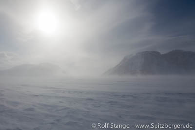
It’s winter in Spitsbergen, but the fjords don’t notice
Temperatures in January and especially February were far above the long-term average (see Spitsbergen-Svalbard.com news: February temperatures in Longyearbyen 15 degrees above average). Now, winter has finally come to Spitsbergen the way it should be, but it looks as if it is too late for the sea water to cool down and allow the fjords to freeze properly. Even fjords that are usually reliably frozen such as Van Mijenfjord, Tempelfjord and inner Wijdefjord are largely open, and fjord ice cover is currently limited to relatively thin sheets in the innermost parts.
Noorderlicht, usually frozen in the ice in Tempelfjord during the spring season, has cancelled the “ship in the ice” for this season and is instead running the first sailing excursions in Isfjord with geology students.
The photo below shows the ice edge in Tempelfjord as of last Saturday (March 29). It is only behind Kapp Schoultz/Kapp Murdoch that the fjord is frozen. The days to come are supposed to be reasonably cold and we hope they may bring more ice. Locals and tourists can chose alternative routes independent of frozen fjords for their excursions, for example to Barentsburg or to the east coast, but the regional environment would greatly benefit from normal ice conditions, for example Ringed seals, which give birth to their offspring on fjord ice later in spring.
The fjord ice edge in Tempelfjord last Saturday (March 29). The fjord is open west of Kapp Schoultz..

Marine biology in the polar night: the dark side of life in the polar seas
As so many other activities in the Arctic, most research activities are very seasonal and largely concentrated in the summer, when working conditions are – well, not easy, but easier than in the polar winter, which brings cold, bad weather and darkness 24 hours a day.
So far it was largely believed that it would somehow be similar with animal life, largely. Of course, polar bears don’t hibernate and reindeer have to look for food 12 months a year, and most animals who can move long distance make sure they spend the winter somewhere more pleasant. But whoever stays, reduces his activity, from movement to metabolism, to a minimum. At least according to common assumptions, largely based on a lack of better knowledge.
Some „light“ has now been shed into this darkness during a research expedition of the Norwegian vessel Helmer Hanssen (formerly known as the Jan Mayen), just a few weeks ago in Kongsfjord. The idea was to make observations and collect data to verify or correct those old assumptions.
In times of a normal day-night-cycle, plankton will move towards the surface to feed during darkness and back into lower, darker water layers at daytime to keep away from predators. This regular movement between food-rich surface waters and the darkness of the deep is the biggest natural movement of biomass on Earth. One of the research questions is if a similar movement is still taking place in times of 24 hour darkness. Even if it will take time for data to be analysed and results to be published, it is already now clear that there is much more activity in the water, including movement, than believed so far.
Predatory fish species are appearently able to find food to a higher degree than assumed. This is one result of analysis of stomach content of fish caught during the expedition with Helmer Hanssen. Fish had prey in their stomach which requires at least a minimum of visual perception to be caught. This indicates that these fish have some kind of night vision, at least to some degree. Eyes of such fish will now be analysed to find out how this might work.
Quite heavy equipment was used for oceanographic work including the movement of organisms in the water column. As a first result, the assumption that arctic fjords are a sleepy place in the polar night can safely be put aside. It is already clear that marine biologists who don’t mind cold and darkness will have a lot of work to do in the years to come.
Similar investigations in the Antarctic have already shown that there is much more activity during the polar night in the south polar sea, too.
Another important research field is the question of the reaction of marine organisms to environmental changes, ranging from low concentrations of oil in the water to climate change which will reduce the ice cover in space, thickness and time and bring higher water temperatures. These questions will involve a lot of laboratory work on fish and plankton caught alive during months and years to come.
The work on Helmer Hanssen in Kongsfjord was coordinated by Norwegian scientists, but involved international researchers. Marine biologists and specialists from all over the world are looking forward to the results.
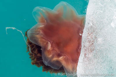
Quite mysterious already at daylight: arctic plankton..
Source: Svalbardposten
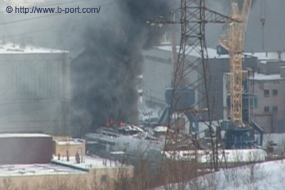
Russian nuclear submarine Krasnodar near Murmansk on fire
The russian nuclear submarine Krasnodar is on fire since Monday morning near Murmansk. Krasnodar is a Oscar II class boat, similar to the Kursk, and one of the last Russian submarines from the days of the Cold War to be taken out of service in 2012 for scrapping.
According to the website Barentsobserver, scrapping a nuclear submarine starts with removal of spent nuclear fuel. Next is removing the rubber cover of the outer hull. This seems to be a dangerous process, as fires of the outer rubber layer during removal have occurred before more than once. It seems as if the present fire is a similar case.
The removal of the nuclear reactors is the last step of scrapping a nuclear submarine. In other words, the 2 reactors are still on board, with considerable amounts of radioactive materials.
Krasnodar is in the Russian navy shipyard Nerpa north of Murmansk, only about 100 km from the Norwegian border. Despite an information exchange agreement, Norwegian authorities were informed by media about the fire before they got any information from official Russian sources. The Norwegian district governor describes a fire on a nuclear submarine as a serious issue.
According to Russian information, no radioactivity has escaped so far.
The burning nuclear submarine Krasnodar in the navy shipyard Nerpa near Murmansk. Foto: b-port.com.
Source: Barentsobserver
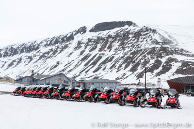
Snow mobile season in Spitsbergen: accidents/important to know
The snow mobile season has started a few weeks ago in Spitsbergen. Some locals start already during the polar night, while most others and most tourists start their snow mobile excursions when the light comes back around mid February. The season lasts as long as snow and ice make it possible to be out, usually into the first days of May or until mid-May if it works well.
Snow mobile excursions make it possible to see amazing places which are otherwise hard to reach, if not impossible for most, but they bear their specific risks. If you don’t know the local terrain and you do not have experience with snow mobiles, then it is definitely a good idea to join a guided group. This is also the official recommendation by the Sysselmannen (governor).
Some incidents of the last couple of weeks:
- In early March, tourists had to be evacuated with helicopters in two cases after having suffered fractures while falling with their snow mobiles or, rather, turning them over in uneven terrain. Both incidents happened near Sassendalen, one in the moraine of Rabotbreen and one in Brattlidalen. Both persons were members of guided groups.
- On Tuesday (March 18), a man had to be airlifted with chest injuries after he had driven his snow mobile over a steep slope, falling down 6 metres. Other members of his group called the rescue forces with mobile phones, but could not provide a position as they did not exactly know where they were. The group was not guided and did not have GPS or local knowledge. The incident happened on the coast between Colesbukta and Barentsburg, a frequently used route, but with several steep slopes which are hard to see and seriously dangerous at inadequate speed.
In another case, a person went unconscious and fell from his snow mobile at low speed in Grønfjord, south of Grøndalen. First aid was given, but his life could not be saved. The information available seems to indicate a heart attack or similar medical emergency.
The first two cases indicate that accidents can naturally also happen while on tour with guided groups. But at least locally knowledgeable guides will make sure adequate speed is being used, which is especially important in case of terrain obstacles such as steep slopes which can be very difficult to see. Adequate speed is of vital importance. Guided groups also have emergency equipment including satellite phones. The mobile phone cover in Spitsbergen is unreliable or, rather, inexistent over wide areas.
For safe tours with snow mobile and ski, the following are recommended or should be considered:
- Avalanche equipment (snow shovel, avalanche probe), unless you stay in clearly avalanche-safe terrain.
- Local knowledge or good advice from people with local experience. GPS with digital map, spare batteries (!), and printed map and compass as a backup.
- Emergency equipment. Prepare for a prolonged stay in the field in case of sudden bad weather or snow mobile breakdown. Communication equipment independent of mobile phone grid such as satellite phone and PLB. Tent, sleeping bag, isolation mattress, camping stove and fuel, extra warm clothes. Be ready to stay out for at least 24 hours in bad weather.
- Rifle and other polar bear safety equipment.
- Stay with an experienced person or join a guided group if you don’t have experience with snow mobiles.
- Make sure you know how to deal with minor, common repairs such as exchanging the v-belt.
- Snow mobiles like to break down, especially when it is most unwelcome. Consider this for any trip further away than you can walk back.
- If you don’t really know the terrain: expect terrain obstacles that are difficult to see.
- Observe regulations: you need helmet and driving license, zero alcohol and, for large parts of Spitsbergen, insurance cover and notification to the administration in advance. There are scooter-free areas. If you don’t know the regulations and boundaries, you have to join someone who does, such as a guided group.
This list is not complete, but it includes some important points.
Rental snow mobiles in Longyearbyen ready to go.
Source: Sysselmannen, Svalbardposten, my own experience.
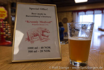
Will Longyearbyen get the northernmost brewery in the world?
On Svalbard, sale and production of alcoholic drinks are currently regulated more strictly than in mainland Norway. Apart from bars and restaurants, alcoholic drinks are only sold by the governmental monopolist “Nordpolet” in Svalbardbutikken in Longyearbyen and there the allowance is limited for everyone. Locals have a card and tourists use their flight ticket to document purchases. Production of alcoholic drinks is completely prohibited, both for commercial purposes and for private consumption.
These regulations are now under reconsideration and it seems they might soon be history. It is four years ago that Robert Johansen contacted the Norwegian Health Department to apply for the concession for a brewery in Longyearbyen. This was not possible under given legislation, but for once, authorities were welling (after all, it was about beer!) so this turned out to start the process for a legislative amendment.
Currently the Norwegian authorities decide on the suspension of the regulations, which date partly back as far as 1929. The Departments of Health and Agriculture did already signal that a change of regulations is welcome and that no reasons are seen against it. If the legislative amendment comes, the production of alcoholic drinks will be made possible as a start. Later the quantitative limitation for the sale of alcohol may be abolished.
If everything proceeds as expected, Robert Johansen wants to offer beer “made in Longyearbyen” as soon as summer 2014. His brewery will be called Svalbard Bryggeri AS and will start with a production of ca. 100.000 liters per year. Sale of related souvenirs is also planned. There are reactions on the expected amendment in Barentsburg as well. There the Russian mining company Trust Arktikugol already applied for the concession for a brewery – which already exists since 2013 as part of the mining company.
When the brewing in Longyearbyen really starts, Svalbard Bryggeri will be the northernmost brewery in the world. Currently Mack Brewery in Tromsø claims this title and it might keep it officially as with an annual production of 100.000 liters Svalbard Bryggeri would be a microbrewery according to Norwegian law. This term describes small breweries with an annual production lower than 600.000 liters. Several mcrobreweries are currently planned in Norway, north of Tromsø, for example in Hammerfest and in the municipality of Gamvik.
The Mack Brewery faces the arising competition positively but as a big brewery it classifies itself in another category. Some years ago for financial reasons the Mack Brewery moved its beer production to Nordkjosbotn wich is located south of Tromsø. Mack nevertheless claims the title “the world´s northernmost brewery” because the company´s headquarter is still in Tromsø.
Beer made in Barentsburg.
Source: Svalbardposten
Arctic drift ice: February cover at fourth lowest extent since 1979
The arctic drift ice cover usually reaches its maximum distribution in mid March. In 2014, however, the February extent was far behind the normal values. The average was 14.4 million square kilometres or 910,000 million square kilometres less than the long-term average. This puts February 2014 on the fourth place in the negativenstatistics since 1979, the beginning of systematic observations.
February 2005 holds so far the absolute negative rekord.
In February 2014, the ice cover grew with about 14,900 square kilometres per day. The corresponding long-term value is, however, 20,300 square kilometres. Short-term fluctuations against the growing trend in February are due to ice movement rather than melting.
In February 2014, the temperatures in large parts of the Arctic were 4 to 8 degrees above the long-term average.
Arctic drift ice: the extent in February was extremely low.
Source: Snow and Ice Data Centre
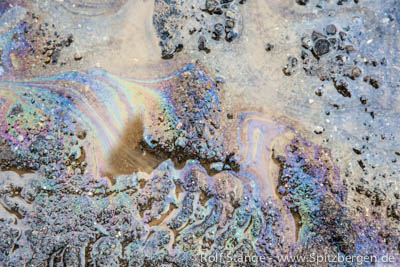
Oil spills in cold climate areas: are and remain uncontrollable
It is almost 25 years ago that the oil tanker Exxon Valdez hit a reef on the south coast of Alaska. The Exxon Valdez achieved sad fame when an alcoholic captain and an overcharged third mate steered the ship on rocks on March 24, 1989. 37,000 tons of crude oil were spilled and polluted 2,000 km of coastline. The result was and is an ecological and economical disaster for a whole region.
Scientists have now had 25 years to study the consequences of an oil spill in cold (but not high arctic) coastal waters. The results are sobering:
- A cleanup of a major spill of crude or heavy oil is impossible. Despite using resources of about 2 billion US-$, Exxon has managed to clean up a mere 7 % of the polluted coastline. After the Deepwater Horizon catastrophe in the Gulf of Mexico, BP has used an astronomic 20 billion US-$ but “cleaned” no more than 3 % of coastline and surface waters, largely by using other toxic chemicals. Conclusion: it is impossible to clean up a spill of heavy or crude oil once it has happened.
- Once damage is a fact, it will last a long time, if not forever. In Alaska, 32 habitats and population have been monitored after the Exxon Valdez disaster. Out of these, only 13 are considered fully “recovered” or “very likely recovered.” Thousands of tons of oil are still in the sediment, polluting their surroundings for a very long time.
- Ecological damage cannot be repaired by man, only by nature itself. To make this possible, ecosystems have to be intact.
- The risks of oil spills, both the likelihood of such an event and the following impact, is usually underestimated or downplayed by authorities and industries.
- Prevention is the only strategy that really makes sense. Currently, the industry tends to a reduce spill risk to “As Low As Reasonably Practicable” (ALARP); instead of “As Low As Possible” (ALAP), regardless of cost” although “prevention is clearly cost-effective”.
- In cold areas, the ecological impact and technical difficulties increase strongly. Any attempt of clean-up in ice waters are highly unrealistic to be successful.
These are some of the key results presented by Professor Steiner in an article in the Huffington Post. On the long term, only abstinence of oil will prevent oil spills. This was one of the demands of the 1989 disaster in Alaska, but the global need for oil has obviously increased dramatically since. Sustainability is not yet a significant factor in decision making in politics and economy.
Small oil spill next to a leaking diesel tank at a station in Antarctica.
Source: Huffington Post
News-Listing live generated at 2025/May/03 at 06:02:42 Uhr (GMT+1)


-
Books, Calendar, Postcards and more

-


