-
current
recommendations- Liefdefjord
New page dedicated to one of Spitsbergen's most beautiful fjords. Background information and many photos.

- New Spitsbergen guidebook
The new edition of my Spitsbergen guidebook is out and available now!
- Liefdefjord
New page dedicated to one of Spitsbergen's most beautiful fjords. Background information and many photos.
-
weather information

| Guidebook: Spitsbergen-Svalbard |
Home → September, 2017
Monthly Archives: September 2017 − News
Several polar bears observed near settlements
Several polar bears have been seen near Longyearbyen and other settlements in the past few weeks.
Polar bears look cute, but can be nasty when they are looking for food
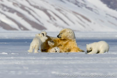
One of the bears – a 17-year-old male – had to be anesthetized and transported by helicopter to Nordaustlandet in the north-east of Spitsbergen, after devastating several huts at Kap Laila River between Longyearbyen and Barentsburg on 15 September. Polar bear expert Jon Aars from the Norwegian Polar Institute confirmed, that this was already the bears second flight with a helicopter. The polar bear was marked as a cub and already registered in 2001, when he destroyed a hut together with his brother and mother. The mother was also observed later in similar burglaries.
This is not an unusual behavior for a polar bear, says Jon Aars. Some polar bears even seem to have specialized in hut burglaries. But to stun the polar bears and fly them out can just be a short-term solution. Last year in April a polar bear from Longyearbyen was flown to the island of Nordaustland several hundred kilometers away. Only one year later he was back at the Isfjorden.
At the beginning of September, a female polar bear with two cubs was observed at Revneset – a few kilometers north of Longyearbyen. Three attempts have already been made to hunt them away by means of a helicopter. The three bears returned twice after a few days and reappeared near Longyearbyen. After the third attempt, the bears have not yet been seen again.
Another polar bear with two cubs was observed near Svea and several bears were seen near Isfjord radio at Kapp Linné the last month.
The fact that so many polar bears appear in the vicinity of human settlements in such a short time does not occur too often, but is probably coincidence. Jon Aars believes that such visits could occur more often in the future, as polar bears have been protected for many years. Genetic research shows that polar bears tend to visit the same areas for several generations. People in Longyearbyen will probably have to get used to frequent visits of polar bears. Or the other way around.
Polar bear mum with cub

Source: Svalbardposten
Italian lost and found
After the search after a sailing boat last week, SAR (search and rescue) forces from Sysselmannen and Red Cross were, only a few days later, again out on a major mission. On Saturday afternoon at 16.20 hours, the local hospital in Longyearbyen received a call from an Italian person who was stuck on a steep slope and not able to move. The man said that he could see the airport, without giving further details about his position. Next to lack of local knowledge, language difficulties may have come in here. He finished the conversation without leaving his name or contact details, so it was not possible to contact him again later.
Hence, SAR forces had to move out in darkness and strong winds. The Red Cross searched Platåberget, which is situated near the airport, with about 30 people. Finally, a light signal was seen on a steep slope above the sea on Fuglefjella, between Bjørndalen and Litle Bjørndalen. Strong winds prevented SAR forces from reaching the area by helicopter, so the Red Cross had to walk a longer distance to get to the site. Shortly after 5 a.m. the man was finally rescued; he had spent at least about 13 hours in his position. All involved got back to Longyearbyen thereafter in good condition.
The incident shows how important it is to have at least basic local knowledge and means of orientation as well as the ability to make a proper emergency call if worst comes to worst. Next to some knowledge of a language used locally, or at least a contact who can provide that, this involves the correct local emergency contacts (the Sysselmannen), name and phone number. The man was in very steep terrain, in darkness, strong wind and without local knowledge and orientation. The incident provides a negative example in several ways.
The steep slope of Fuglefjella between Bjørndalen and Litle Grumantdalen on a nice summer day, where an Italian tourist was rescued early Sunday morning in darkness and wind.
Source: Svalbardposten
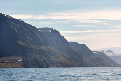
Sailing boat lost and found
There have been strong winds up to storm force in northern Spitsbergen yesterday (Monday). Two smaller boats seem to have gotten into potentially serious difficulties. Emergency signals have been triggered and search and rescue forces are in the area with helicopters and coast guard ships.
SV Antigua (where the present author is on board) is also in the area, but we did not have more problems than some cases of seasickness during our sailing passage yesterday. So SV Antigua is NOT affected by any serious problems.
Update: after several hours searching in the northwest of Spitsbergen, where also several tourist ships including SV Antigua assisted, the boat was on Tuesday found „in good condition“. The SAR mission was officially abandoned by the coast guard. It was later stated that it was a local boat from Longyearbyen. The emergency signal position was from Magdalenefjord, while the boat was found in Wijdefjord, almost 100 km away as the ivory gull flies. The emergency signal had been trigger automatically without the crew being aware of it; probably, the emergency beacon was lost in heavy seas and triggered itself.
Wind force 8 on Monday at the north coast of Spitsbergen. Photo © Alexander Lembke.

Strong wind up to storm force in North Spitsbergen
There have been strong winds up to storm force in northern Spitsbergen yesterday (Monday – 2017/09/18). Two smaller boats seem to have gotten into potentially serious difficulties. Emergency signals have been triggered and search and rescue forces are in the area with helicopters and coast guard ships.
SV Antigua (where the present author is on board) is also in the area, but we did not have more problems than some cases of seasickness during our sailing passage yesterday. So SV Antigua is NOT affected by any serious problems.
Update: after several hours searching in the northwest of Spitsbergen, where SV Antigua also assisted, the boat was found »in good condition«. The SAR mission was officially abandoned by the coast guard. At the moment, no further details regarding the identity of the boat or other are available.
Update: According to Svalbardposten, it was a local sailing boat from Longyearbyen. The emergency beacon was lost and automatically activated during heavy weather. The crew was not aware of that.
Source: Rolf Stange via OnSat-Mail directly from SV Antigua
1600 liters of diesel lost in Mimerdalen
1600 litres of diesel were lost on Friday during a helicopter flight in Mimerdalen near Pyramiden. The fuel was hanging under the helicopter to be transported to a station on a mountain west of Pyramiden operated by Longyearbyen airport for aerial navigation.
A rope broke during the flight, so the diesel fell down and crashed on the gravel plain of the river bed. It could not be retrieved and was lost in the environment: in the river gravel, one of the many small rivers or finally in the fjord.
The helicopter was operated by Lufttransport, a company that is also responsible for the helicopter logistics of the Sysselmannen, including Search and Rescue operations. The incident is currently under investigation.
Mimerdalen near Pyramiden, where 1600 litres of Diesel were lost from a helicopter on Friday.
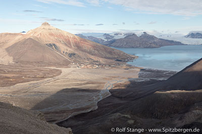
Quelle: Svalbardposten
Summer hiking route up to Larsbreen destroyed by landslide
The mountains and glaciers around Longyearbyen have a lot of great hiking opportunities. Right now it looks like there is one less: the western part of the moraine of Larsbreen, which is part of the popular summer route ascending Larsbreen towards the glacier itself or the near-by mountains (Trollsteinen, Sarkofagen) has been strongly affected by landslides this summer. This is generally a natural process in a moraine area that consists of a thing layer of sediment resting on steep slopes of clear glacier ice. The area had already been affected by minor landslides in recent years.
This summer’s landslides took the area with the hiking route from Longyeardalen up to Larsbreen. Now, there is a steep slope of mostly exposed glacier ice covered with a thin layer of sediment (mud and stones). The “way” below the slope is exposed to further landslides and rockfalls and hence currently not a safe alternative.
It remains to be seen if the winter route can still be used. Winter and summer routes are slightly different and frost and snow change the terrain significantly. Meanwhile, Longyearbreen and Vannledningsdalen remain generally available as hiking routes up to Larsbreen, Sarkofagen and Trollsteinen.
View from Gruvefjellet to the moraine of Larsbreen. The area recently affected by landslides is roughly marked by the red circle (the photo was taken before these landslides happened).

News-Listing live generated at 2025/May/04 at 03:16:45 Uhr (GMT+1)


-
Books, Calendar, Postcards and more

-


