-
current
recommendations- Liefdefjord
New page dedicated to one of Spitsbergen's most beautiful fjords. Background information and many photos.

- New Spitsbergen guidebook
The new edition of my Spitsbergen guidebook is out and available now!
- Liefdefjord
New page dedicated to one of Spitsbergen's most beautiful fjords. Background information and many photos.
-
weather information

| Guidebook: Spitsbergen-Svalbard |
Home →
Yearly Archives: 2017 − News
2017: my year in review – February and March: the Antarctic Odyssey
After finishing the big project with my new Norwegian guidebook Svalbard – Norge nærmest Nordpolen, it was time to get some fresh air. And I got lots of it during a trip around the world in February in March. The heart of this huge voyage was a semi-circumnavigation of Antarctica, which I refer to as the “Antarctic Odyssey”. Starting in New Zealand, we went to Campbell Island, into the Ross Sea and then via Peter I Island to the Antarctic Peninsula before we finished in Ushuaia. Truly an Odyssey!
The highlight of this great journey? Hard to say. There was not only one highlight. Just the dimensions of this trip are epic, many thousand nautical miles in more than 30 days. Being Expedition Leader on such a trip on the Ortelius was certainly a contribution towards making it interesting for me. Normally, “my” ships are much smaller these days, and they do not carry 3 helicopters!
Thinking about which impression still means a lot to me and will stay for a long time, then Campbell Island is quickly coming to my mind. This island, which belongs to the New Zealand subantarctic islands, was very high on my personal wishlist – simply as I had not been there before. Well, I had been very close 2 years earlier, but then, there was no chance of making a landing because of very strong winds. This time, we had just the portion of luck that you need in a place like that.
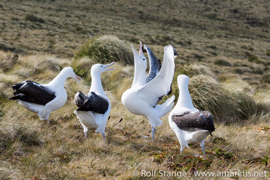
Albatrosses on Campbell Island.
Of course, flying into Taylor Valley, one of the famous McMurdo Dry Valleys, and to McMurdo Base, where we almost stayed quite a bit longer than we actually wanted to, are experiences never to be forgotten. And that is generally true for all impressions of Antarctica from a bird’s perspective.
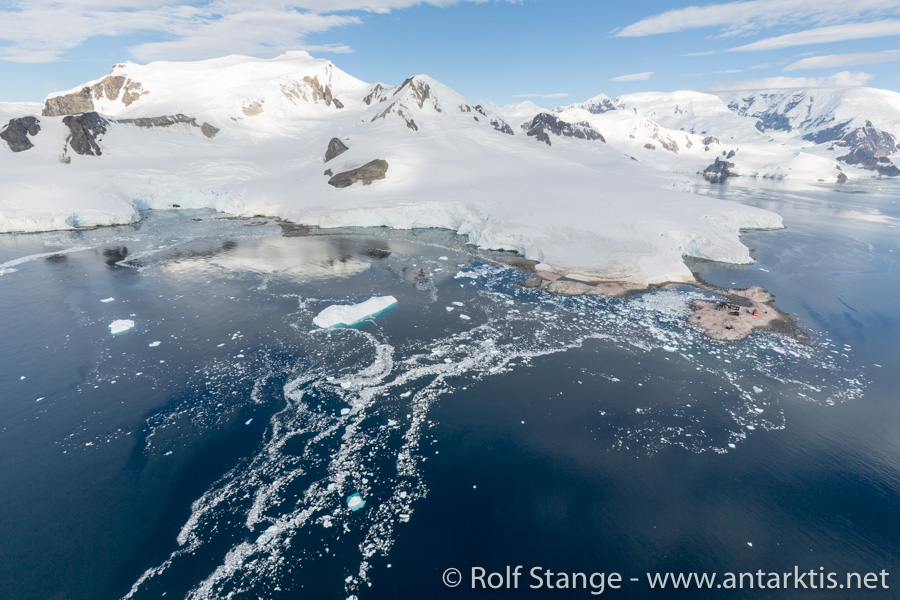
Waterboat Point (Antarctic Peninsula) from the air.
But in the end, it is the direct encounters with the wildlife and the scenery that is always getting very close to my heart and soul. That is what stays! The Albatrosses on Campbell Island, the Emperor penguins in the Ross Sea, the Humpback whales and penguins in the Antarctic peninsula, to mention a few of these encounters. Memories that will stay forever!
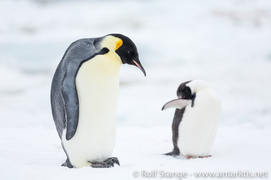
Emperor and Adelie penguin at Cape Hallet in the Ross Sea.
2017: my year in review
It is almost frightening how time is flying. Again, a year almost gone! It was an intense, rich year. What did the last 12 months bring, for Spitsbergen, for spitsbergen-svalbard.com and for me? I’ll review the year with a couple of blogs over the next days.
January is polar night in the far north. A good time for writing table adventures. Writing arctic books is not boring, but the actual process is often not terribly exciting. In practice, it means to spend an awful lot of time on the computer. Researching, writing, editing, looking for images, processing images, making illustrations and so on and so forth.
In January 2017, my biggest project in many years was about to be finished. I can tell you that it was not boring! For a long time already, I had had dreams of a Norwegian translation of my Spitsbergen guidebook. And in 2015, I was brave or crazy enough to go ahead with it. Intense work on every opportunity for a good year, involving a number of native speakers who helped me in translating and “språkvask” (proofreading language). I am still almost feeling dizzy when I bring these weeks and months, which were very intense, back to my inner eye. I don’t want to bother you with the details of the process, but it was without exaggeration certainly my biggest project since the very first version of the Spitsbergen guidebook came out in 2007 (that was the first German edition, that very heavy book, if anyone remembers). And at the same time, I had a little series of presentations, while public attention in Longyearbyen was turned on a polar bear family who had settled down for a while in the neighbourhood of town. A polar bear family, mother with 2 cubs, even walked through way 238 (the neighbourhood close to Adventdalen, lowermost road – that’s where we also have our little home).
And I did manage to finalize the files with the Norwegian book for printing before I went down to Antarctic in February. Halleluja!
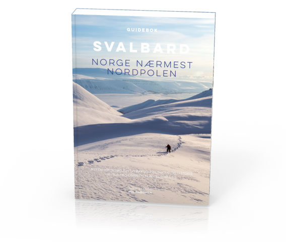
My arctic adventure in early 2017: Svalbard – Norge nærmest Nordpolen.
More evacuations on the anniversary of the 2015 avalanche in Longyearbyen
Update (21 December): The weather has calmed down again and after checking relevant avalanche-prone slopes, the authorities have decided to lift the traffic ban that was implemented on Monday.
The evacuations from last week, concerning the upper row of houses in Lia, remains in force until further notice (end of update).
It seems almost strange: exactly 2 years after the fatal avalanche in Longyearbyen, the weather forecast for today (19 December) seems almost exactly the same as it was just before snow masses killed two people in their homes on 19 December, 2015. Winds up to 20 m/s from southeasterly directions and strong precipitation are expected during the evening.
For tonight, a commemoration ceremony was scheduled for the victims of the fatal 2015 avalanche. But it seems as if many people’s attention will rather be demanded by today’s situation and events. Some days ago, the Sysselmannen had already issued an order to evacuate parts of Longyearbyen. This was to be in force on 22 December and based on the general avalanche risk, rather than the actual weather and avalanche situation. After new weather forecasts were released, this measure came into force already yesterday (18 December) at 22 p.m.
At the same time, the evacuation zone was extended to include more houses in Lia, the part of Longyearbyen that was hit in 2015 (“Spisshusene”, the coloured wooden houses between the centre and the mountain Sukkertoppen) and parts of Nybyen (all houses on the east side of the road).
The evacuations are in force until further notice. Some addresses may not be accessible for months.

Large parts of Nybyen and Lia in Longyearbyen are now evacuated because of the current and general avalanche risk.
Houses in Longyearbyen evacuated: residual risk of avalanches too high despite local warning system
Soon it will be two years ago that the avalanche came down from the mountain Sukkertoppen that destroyed eleven houses and took two lives. There will be a memorial ceremony in Longyearbyen on the day, 19 December.
The avalanche area in Longyearbyen in December 2015. Two people were killed and eleven houses destroyed. One was moved as much as 80 metres. Photo © Svalbardposten.
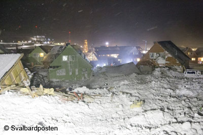
There has been – and still is – a lot of talking about the avalanche risk in Longyearbyen on all levels. It seems obvious that there have been neglects on various public levels, but it was said officially that there is no institution or individual that may legally be held responsible.
And there is, of course, the question of how to deal with the avalanche risk in future. An official report about the avalanche situation has determined that a large number of houses in Longyearbyen is exposed to various levels of avalanche risk. A local warning system has been established, which has produced mixed results so far; on one occasion, the system produced a false security statement that was spectacularly wrong. Two houses were destroyed on that occasion, and it was a matter of luck that there was no loss of human life. Instruments to measure the thickness of the snow layer have been installed on various slopes close to Longyearbyen. These instruments are supposed to provide real-time data about snow accumulation in locations where people had to measure manually in the past, something that is often difficult or even impossible in situations of severe weather when an increased risk has to be assumed. But that is obviously exactly when you need that kind of data, so these new decives are expect to make a significant improvement to the avalanche warning system.
Avalanche barriers are another measure expected in the future, but they are not there yet, almost two years after the big, tragic 2015 event. Evacuating parts of Longyearbyen, on a situative or permanent basis, is also one of the options which are discussed. The financial aspects of all that is yet another issue.
It does, however, not cost the public much to evacuate certain addresses on a preventive basis. Evacuating parts of Longyearbyen has become a standard procedure during winters since late 2015. Yesterday (14 December), the Sysselmannen has issued an order that certain addresses have to be left until 22 December until further notice. This measure is expected to be in force until the snow is gone, which means, the houses will not be available for months.

These parts of Longyearbyen (marked red) will be evacuated from 22 December until further notice. The complete map is available from the Sysselmannen.
So far, evacuations were made in or before an actual risk situation, based on snow conditions, weather forecasts etc. This time, however, there is no such base for the evacuation, something that becomes clear from the time span of 8 days between the issue of the evacuation order and the date (22 Dec) when it actually enters force. Sysselmannen Kjerstin Askholt says “The ban on traffic is based on the risk evaluation for individuals and public safety, because this area is especially exposed to avalanches. The current practice with a local avalanche warning system and possible evacuations, based on technical advice from avalanche experts, does not exclude a high residual risk and remaining uncertainties, so the houses in question can not be used while there are no measures for avalanche safety in place” (Sysselmannen, auhtor’s translation).
Areas concerned are addresses in way 222 and 226, which are located directly next to the mountain Sukkertoppen, but may be extended to other areas at any time as deemed necessary by authorities.
Evacuating a number of houses for a longer period of time based on general precautionary reasons rather than an actual risk situation appears to be a drastic step, compared to the impact that this has on the lives of those who have to leave their homes for months. There are those who have, next to their home in the area concerned, rented a place elsewhere in Longyearbyen on a permanent basis, something that obviously involves high costs and this is not a contribution to the already difficult housing market in Longyearbyen either. Those who own a place in the area that is affected, are also faced with a substantially difficult situation.
Not a glorious chapter for politics, considering the current development started with the avalance in December 2015 – two years ago.
Source: Sysselmannen
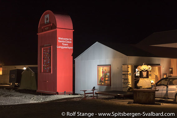
Santa Claus’ Letterbox – 20th November 2017
If you have been to Longyearbyen since December 2013, then you have seen the huge, red letterbox just upon entering town, as you came from the airport. This was the Santa Claus Mailbox, and here you could post your letters to Santa Claus.
The letterbox was an idea from Po Lin Lee from Honkong, but she did not just send an idea and money from far away. She was and is in Longyearbyen and puts a lot of effort into hear postal project. But – the permission to have it standing there was only temporary. It ran out on December 2015, and then, the letterbox was to be removed again, or a new permission had to be obtained.
Neither of this happened, until Monday. What happened, was a fight that took a lot of time and energy. Letters, admonitions and warnings were written, bureaucrats and lawyers did what bureaucrats and lawyers do. Neighbours would have to be contacted to give their consent to a renewed permission for the letterbox to remain in place, but is is said that this never happened. Language difficulties seem to have played a role.
Then, the local administration (Longyearbyen Lokalstyre, LL) set a deadline: the letterbox was to disappear on Monday, November 20, 2017. The order to remove it had already been given by LL to a local construction firm. The invoice about the substantial amount of 129,000 NOK (about 13,300 Euro) was in the end to be paid by Po Lin Lee.
Who reacted by ordering a company from the mainland to take the letterbox down in a more carefuly way, so it could be re-built again later somewhere else. Before that happened, Po Lin Lee gave visitors a last chance to visit the letterbox, only to find out that the door had been firmly locked with big screws – without her, the owner, knowing about it. Also, there were traces of forecul break-in on the door, possibly from a local company who had already removed the electrical system on behalf of the local administration.
Gallery – Santa Claus’ Letterbox – 20th November 2017
- gallery anchor link: #gallery_1363
Click on thumbnail to open an enlarged version of the specific photo.


Meanwhile, the discussion in local social media group had gained some momentum. Some were happy that local democracy had won a victory and the letterbox was now about to disappear, while others expressed sadness. There are different opinions regarding the question if Longyearbyen should be presented to the global public as a Santa Claus Town. The local legend actually says that Santa Claus lives in Mine 7b, above Nybyen. During the Christmas period, there is light up there, and there is a letterbox (of more conventional dimensions) next to the road below it, where children can send their letters to Santa Claus as part of the local christmas happenings.
The big Santa Claus letterbox was now removed by a company on behalf of Po Lin Lee. According to her, there are several interested parties that might step in and take over the letterbox to put it up again elsewhere in Scandinavia. And Po Lin Lee has not given up hopes that she might actually be able again to put it up somewhere else in Longyearbyen.
Happy Christmas time to everybody!
More arctic Christmas stories? – Click here to check out my (German) book with historical Christmas stories from high latitudes.
Historical
Christmas stories
(German)

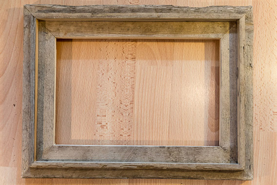
Picture frames made of Spitsbergen-driftwood available for the first time in limited edition
During a walk on any of Spitsbergen’s beautiful beaches, you can’t help it but be amazed about the impressive amounts of driftwood. Not only does it add a aesthetical aspect to the otherwise rather sterile shoreline, but it does also have a fascinating history: Just as Fridtjof Nansen did with his famous ship the Fram, did the wood drift all the way from Siberia with the pack ice across the Arctic Ocean and all the way to the north Atlantic, where it was thrown onto an arctic beach in Svalbard, Greenland, Iceland, Jan Mayen or Frans Josef Land.
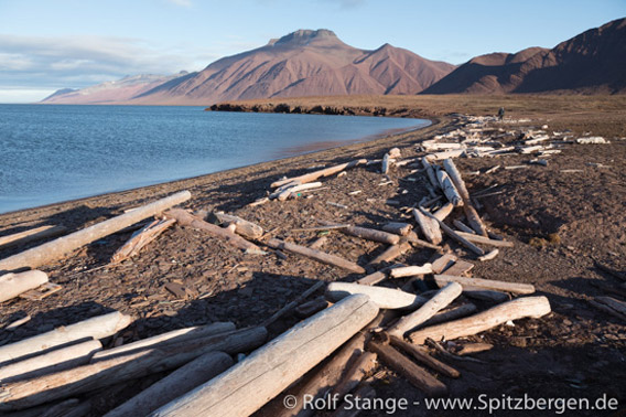
Driftwood at Wigdehlpynten – Woodfjord, Spitsbergen
And there we have it. If you are a trapper, you can use it to build a hut (that was rarely done, too much effort) or as firewood (that was very common). I am not a trapper, but a photographer, so it was an obvious idea to use the driftwood to make picture frames. Can you imagine a more appropriate picture frame for arctic pictures than one made of driftwood from Spitsbergen?
Turning driftood into picture frames required more effort than we expected to begin with. We made the first serious attempts several years ago, when master carpenter Wolfgang Zach opened his carpenter’s workshop in Longyearbyen. He called his little company “Alt i 3”, which is a play of words: “3” is “tre” in Norwegian, which also means “tree” or “wood” at the same time. So it translates to “Everything out of wood”. We found also out that you do actually need a license to export driftwood from Spitsbergen, so that was another thing we had to take care of.
So I started collecting driftwood in small amounts. The first project was a bookshelf for our flat in Longyearbyen, and at the same time we started making the first prototypes of picture frames. We just had to find out what works well with this very special material. One of the discoveries that we made was that if you cut and sand it, it looks as fresh and new as a wooden board that you just bought in the building supply store. Which is of course not the idea with picture frames made from arctic driftwood. So I started looking for pieces of wood that had a good shape to start with. Most pieces of driftwood are not natural, but rather trees cut in forestry in Siberia or even ready-made boards. Completely natural driftwood – trees with roots – are actually quite rare.
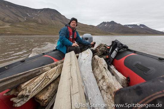
Rolf Stange transporting driftwood to Longyearbyen.
I took this driftwood in small amounts to Longyearbyen, were it had to be stored and slowly dried over longer periods of time. Then, Wolfgang and I could start making the first picture frames in his carpenter’s workshop. After some experimenting, we had a prototype that we both liked, so the master carpenter could start to produce the first set of 16 picture frames – all of them were made by Wolfgang Zach in Longyearbyen.
Now, these had to get to Germany. If you know me, then it won’t surprise you to read that they travelled from Spitsbergen to Franeker in the Netherlands on the good sailing ship Antigua and from there via Münster and Dresden to my shipping department in northeastern Germany.
After this long journey from Siberia, down a river, with the ice across the Arctic Ocean to a beach in Spitsbergen, from there to Longyearbyen to Wolfang’s carpenter’s workshop, from there on a sailing ship to Europe. And there they are now, the very first series of 16 picture frames from Spitsbergen driftwood, available for the first time since November 2017.
Every single picture frame is a unique specimen. This has to do with the history of the wood, the natural character of the material, the manual production. So I took photographs of all frames, which you can see on this page (click here), which also has all the technical information (dimensions, price etc.)

New 360° panorama: Ballstad, Lofoten
A new panorama on this site gives a 360 degree view of Ballstad on Vestvågøy, one of the Lofoten islands in north Norway. I shot it freehand and the weather was quite typical November.
Part of the new panorama of Ballstad (Lofoten).

Spitsbergen-calender 2018: the east coast
In February, the Spitsbergen-calendar 2018 takes us to the east coast. In the winter season, this is a popular destination for snowmobile day-trips, enabling relatively many people to see this grand winter scenery. Storfjorden is frozen to fast ice here in Mohnbukta, and some smaller bits and pieces of glacier ice are stuck in the ice. They broke off last summer from the combined glacier fronts of Königsbergbreen/Hayesbreen/Heuglinbreen, of which we can see a small part in the background.
It is quite common that polar bears are roaming through this icy landscape. We will see if we are lucky enough to spot them somewhere later …
The sun is just starting to rise above the horizon in Spitsbergen in mid-February, and the days are still short. It is still too early for longer trips. But the light can be breathtakingly beautiful!

Spitsbergen-Calendar 2018: February. Ice-landscape on the east coast.
Russian helicopter wreck lifted
The wreck of the Russian helicopter that crashed into Isfjord close to Barentsburg previous Thursday was lifted last night. The special ship Maersk Forza was brought to Spitsbergen for this task and completed the work successfully on the night from Friday to Saturday. There were 8 persons on board the MI-8-helicopter when it crashed, including 5 crew members and 3 scientists. One body had already been found some days ago about 130 m away from the wreck. There is no trace so far from the other crew members, and the search for them will be continued.
The cockpit voice recorder could secured together with GPS units which are expected to have the actual flight track saved. They will be brought to Moskva for further investigations.
Meanwhile, questions are raised regarding the cause of the crash and the circumstances of the flight. The data recorders that were secured are likely to shed light on the actual crash. It seems that the flight was not legal according to applicable Norwegian legislation. The Norwegian flight permit issued to the operator covers only flights in direct combination to the operations of the mining company Trust Arktikugol, for example transport of company employees between Longyearbyen and Barentsburg. Commercial flights and transportation of tourists and scientists are explicitely excluded.
There were 3 scientists on board the helicopter when it crashed.
The wreck of the Russian helicopter, which crashed on October 26 close to Barentsburg into Isfjord, on board the ship Maersk Forza (photo © SHT).

Source: Svalbardposten
Helicopter crash: wreck soon to be lifted
The wreck of the Russian helicopter that crashed into Isfjord last week was identified on photos taken by a dive roboter from the research vessel Ossian Sars. The MI-8 helicopter is lying on the sea floor at a depth of 209 metres in Isfjord, about 2 km from the Russian helicopter base at Heerodden close to Barentsburg.
One body was found in a distance of 130 metres to the wreck. It is already in Longyearbyen. There is no hope that any of the 8 people in the helicopter, 5 crew and 3 scientists, survived.
The Norwegian authority for traffic disasters (Statens havarikommisjon for transport, SHT) is now in charge of further investigations. A salvage vessel is expected to arrive in Longyearbyen on Thursday. The uplifting operations will start as soon as the vessel is in position at the accident site. Russian specialists are in Longyearbyen to support the Norwegian forces under Norwegian leadership. When the wreck is lifted, it will be taken to the Norwegian mainland for further investigations. SHT is currently conducting interviews with witnesses and collecting various data including weather, the condition of the helicopter, qualification of the crew and more.
Photo by a dive roboter of the research vessel Ossian Sars used to identify the wreck (image © G.O. Sars).

Source: SHT
Helicopter crash: wreck found
The wreck of the Russian helicopter that went missing on Thursday afternoon is now most likely found. A ROV (Remotely Operated Vehicle) of the Norwegian Navy has localized an object at a depth of 209 metres on the sea floor that appears to be the wreck of the MI-8 helicopter. The ROV named “Hugin” and another ROV of the research vessel Ossian Sars will continue to gather data to identify the object and to find the missing persons. There were 8 people in the helicopter when it crashed on Thursday. No traces of survivors could be found.
The position is 2.2 kilometres northeast of the Russian helicopter base at Heerodden close to Barentsburg.
A Russian aeroplane has brought divers and other specialists from Russia to Longyearbyen to take part in the operation under Norwegian leadership.
Diving roboter Hugin of the Norwegian navy searching after the crashed helicopter near Heerodden.

Sources: NRK, Svalbardposten
Helicoptercrash: little hope to find survivors
There is no certainty yet if the object that was located by echolot in a depth of 200-250 metres on the sea floor in Isfjord, not far from the Russian helicopter base at Heerodden close to Barentsburg, actually is the wreck of the helicopter. But there is no doubt that the MI-8 helicopter did crash into Isfjord yesterday. As more than 20 hours have gone by since the crash and there is no trace yet of any survivors, hopes to find any of the 8 people on board are getting smaller and smaller and the worst has to be feared.
Names of the 8 persons on board were already yesterday released by Russian media. Now, also the responsible Norwegian authority, the Rescue Centre North Norway, has released the names officially.
The persons on board the helicopter were
Passengers (Scientists of the Instituts for Arctic and Antarctic Research in St. Petersburg):
Oleg Golovanov
Nikolaj Fadejev
Maksim Kaulio
Crew:
Jevgenij Baranov – Chief pilot
Vladimir Frolov – Second pilot
Aleksej Pouljauskas – Mechanic
Marat Mikhtarov – Technician
Aleksej Koroljov – Engineer
There is hope until the opposite is proven, and every effort is taken to continue the search and find survivors. Norwegian SAR forces are on location with helicopters, a special aeroplane from the Norwegian airforce, ships and boats. But the more time is going by, the more likely it seems that it is a tragedy without survivors.
The Sysselmannen has established a contact phone number for relatives and expresses deep sympathy with those who are affected. This is shared by the author of these lines, whose thoughts and sympathy are also with those who were in the helicopter and their family, friends and colleagues and all others who are involved.
According to international law, Norwegian authorities are responsible for the investigation of the accident. A havary commission is already in Longyearbyen and will soon start to gather all information that is available. But currently, the effort to find survivors and the helicopter are still the focus of all efforts.
Russian MI-8 helicopter at the airport Longyearbyen (archive image).

Source: Sysselmannen, Svalbardposten
Crashed helicopter probably found
The Russian helicopter that crashed on Thursday afternoon is probably found. Search-and-rescue forces sensed a strong smell of fuel and saw air bubbles coming to the water surface at a certain position in the area in question, in Isfjord, about 2-3 km from the helicopter base at Heerodden. A ship has found an object on the sea floor with the echolot that could be the wreck of the helicopter or a part of it. This needs to be confirmed, though. The depth is between 200 and 250 metres, far beyond the reach of divers.
Already during the night, a diving robot (ROV = Remotely Operated Vehicle) was brought from mainland Norway to Longyearbyen with a SAS plane. The ROV will be operated at the alleged accident site as soon as possible. This has probably already happened at the time of writing (08.30 local time on Friday morning) or it may be going on right now.
There were 8 persons on board the helicopter, and the search after survivors is going on. SAR forces are searching the nearby coast, east of Heerodden. Helicopters and ships are scanning the water. According to all that is known, the worst has to be feared, but all efforts are taken to find survivors. The Russian helicopter was of the type MI-8, which is equipped with a life raft and with lifting bodies that keep the helicopter afloat at least for a while in case of a controlled emergency landing on the water surface. The fact that no emergency signal was released by the crew makes it however doubtful that it was a controlled emergency landing. A sudden, uncontrolled crash seems likely. Witnesses say they have heard a loud noise like a bang at the time in question.
Next to the 2 Norwegian SAR helicopters, there is a number of ships and boats in the area: Polarsyssel (Sysselmannen), coast guard and boats from the tourism industry in Longyearbyen. Initially, the visibility was reduced by snow fall, but the weather is by now quite good, with little wind and clear visibility. The polar night has begun a couple of days ago, so even around noon, the sun remains below the horizon, making light very scarce.
Light conditions in Isfjord during the polar night around noon. The bright light is the moon. (Archive image.)

Source: Svalbardposten
Russian helicopter crashed near Barentsburg
There will be updates (see bottom end of this article) as further information becomes available.
A Russian MI-8 helicopter crashed near Barentsburg and fell into the sea in Isfjord. The helicopter was on the way from Pyramiden to Barentsburg with 8 persons on board.
The emergency call from the airport tower Longyearbyen was received at 15.35 local time by the emergency response centre North Norway. Norwegian search and rescue (SAR) forces are on location with helicopter and ships. The crash site is in the Isfjord, 2-3 kilometres away from Heerodden, the Russian helicopter base at Barentsburg.
No information is currently available regarding the condition of the 8 persons on board. There is a breeze (7-8 m/s) and the visibility is affected by snowfall.
According to Norwegian law, the Russian helicopters in Spitsbergen are only allowed to fly for company purposes. Charter flights, for example for film teams or scientists, are not permitted. This makes it likely that the 8 people on board were employees of the owner of the helicopter, Trust Arktikugol.
Update: next to the pilot (Baranov Evgeny), co-pilot (Frolov Vladimir), flight engineer (Alexei Poulyauskas), a technician (Mihtar Marat), and an engineer (Korolev Aleksey), there were 3 scientists of the Institute for Arctic and Antarctic Research in St. Petersburg on board: Golovanov Oleg, Fadeev Nicholas, Kaulio Maksim. The names were released in the Russian press.
Update: Dmitrij Zjeljazkov, director of Konvers Avia, the company that owns and operates the helicopter, has told the Russian news agency Tass that the 3 passengers were miners of the Trust Arktikugol.
Russian MI-8 helicopter at the airport Longyearbyen (archive image).
Source: NRK
Spitsbergen-calendar 2018: frozen waterfall in January
In the high arctic, January is icy cold – usually at least. Sometimes, spells of mild air masses from the Atlantic can bring temperatures fluctuating around zero degrees and rain. That was not totally unknown in the first half of the 20th century eithe, but it is certainly more frequent in the times of climate change. But normally, it is really cold! The temperatures will make every river and every waterfall freeze solid.
The January page of the Spitsbergen calendar 2018 shows the waterfall Hyperittfossen in De Geerdalen, about 20 km northeast of Longyearbyen as the ivory gull flies. The watermasses that fall down over basaltic rock cliffs are quite impressive in the summer. Now in the winter, the water is frozen to create structures like organ pipes. I used a rather extreme 11 mm wide angle lense to capture the perspective. It is not every year that the shapes of the frozen waterfall are so impressive: when I took this panorama of Hyperittfossen some years ago, most of the icy structures were hidden under snow.

Spitsbergen-Calendar 2018: January. Frozen waterfall.
News-Listing live generated at 2025/May/04 at 03:51:56 Uhr (GMT+1)


-
Books, Calendar, Postcards and more

-


